
Page 54 - Modern Spatiotemporal Geostatistics
P. 54
Spatiotemporal Geometry 35
2. The non-Euclidean group of coordinate systems, which assumes that
the Euclidean geometry is not necessarily valid (certain of the Euclidean axioms,
postulates, or theorems are violated). This group includes the Gaussian and
Riemannian coordinate systems (see "Non-Euclidean coordinate systems" on
p. 38).
The general curvilinear system introduced above can be used to coordi-
nate events and processes in association with many kinds of geometries. Before
proceeding with the detailed discussion of the coordinate systems used in mod-
ern spatiotemporal geostatistics, an issue worth emphasizing is the possibility of
using global as well as local coordinate systems. In many geostatistical applica-
tions a single global coordinate system covers the whole space/time continuum
of interest. But it is also possible that a global coordinate system is inappropri-
ate in several other applications and local coordinate systems should be used
instead. In other words, we may need to work with coordinate systems which
cover only a portion of space/time and offer an internal visualization of the
domain (these systems are sometimes called coordinate patches). The above
notions are important in the development of certain non-Euclidean coordinate
systems described in the following sections.
Euclidean coordinate systems
The most common Euclidean coordinate systems are essentially special cases
of the orthogonal curvilinear systems mentioned above. In n = 2 or 3 spatial
dimensions, the Euclidean group includes: (i.) The rectangular (Cartesian)
coordinate system (n = 2 or 3; si,..., s n). (ii.) Non-rectangular coordinate
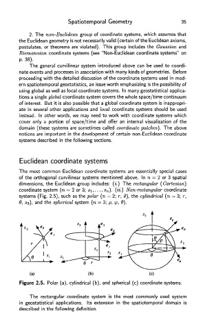
systems (Fig. 2.5), such as the polar (n = 2; r, 0), the cylindrical (n = 3; r,
0, 33), and the spherical system (n = 3; p, tp, d).
Figure 2.5. Polar (a), cylindrical (b), and spherical (c) coordinate systems.
The rectangular coordinate system is the most commonly used system
in geostatistical applications. Its extension in the spatiotemporal domain is
described in the following definition.