
Page 194 - Pipeline Risk Management Manual Ideas, Techniques, and Resources
P. 194
Receptors 71171
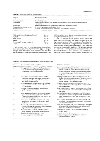
Table 7.21 Bases for evaluation of various receptors
Receptor Basis of categorization
Human populations Housebuilding counts
Groundwater Distance to public drinking water facilities in various geologic formations; special hydrogeological
evaluation
Surface water Stream characterization; flow path modeling; criticality of water; scoring model
Threatened and endangered species Government agencies; studies; field spot checks
Recreational areas Parklands; rivenistreams upstream of parklands; aquifers feeding parklands
Public lands (national parks and forests) 0-5 pts might be pushed to the decision phase rather than the assess-
Wetlands &5 pts ment phase of risk management.
Water intakes 0-5 pts Table 7.22 presents another possible scoring scheme for
Waters 0-5 pts some environmental issues and HVAs. In this scheme, the
Commercially navigable waterways 0-5 pts higher scores represent higher consequences. This table estab-
Total 45 pts lishes some equivalencies among various environmental and
other receptors, including population density. These equivalen-
This approach might be more controversial because judg- cies may not be appropriate in all cases.This table was designed
ments are made that directly value certain types of receptor to be used with a 4-point population density classification (the
damages more than others. Note, however, that the other 4 classes defined by DOT). It proposes a 1-to 5-point scale to
approaches are also faced with such judgments although they include scores not only for population density, but also for envi-
Table 7.22 Scoring for environmental sensitivity and/or high-value areas
Score Environmental sensitiviw descriptions High-value descriptions
0.9 Nesting grounds or nursing areas of endangered species; Rare equipment; hard to replace facilities; extensive associated
vital sites for species propagation; high concentration damages would be felt on loss of facilities; major costs of
of individuals of an endangered species. business interruptions anticipated; most serious repercussions
are anticipated; high degree ofpuhlic outcry; nationalhterna-
tional news.
0.8 Freshwater swamps and marshes; saltwater marshes; Very high property values; high costs and high likellhood of
mangroves; vulnerable water intakes for community business interruption; expensive industry shutdowns required;
water supplies (surface or groundwater intakes); widespread community disruptions are expected high
very serious damage potential. publicity regionally, some national coverage.
0.7 Significant additional damages expected due to difficult Moderate business interruptions anticipated; well-known or
access or extensive remediation; serious harm is done important historical or archaeological sites; a degree of public
by a pipeline leak. outrage is anticipated.
0.6 Shorelines with rip rap structures or gravel beaches; Long-term (one growing season or more) damage to agriculture;
gently sloping gravel riverbanks. other associated costs; some community disruption; regional
news stories.
0.5 Mixed sand and gravel beaches; gently sloping sand and Low-profile historical and archaeological sites; high-expense
gravel river banks; topography that promotes wider cleanup area due to access, equipment needs, or other factors
dispersion (slopes, soil conditions, water currents, etc.); unique to this area; high level of local public concern would
more serious damage potential. he seen.
0.4 Coarse-grained sand beaches; sandy river bars; gently Unusual public interest in this site; high-profile locations such
sloping sandy river hanks; national and state parks as recreation areas; some industry interruption (without major
and forests. costs); local news coverage.
0.3 Fine-grained sand beaches; eroding scarps; exposed, Some level of associated costs, higher than normal, is anticipated;
eroding river banks; difficulties expected in remediation; limited-use buildings (warehouses, storage facilities. small
higher than “normal” spill dispersal. offices, etc.) might have access restricted.
0.2 Wave-cut platforms in bedrock; bedrock river hanks; Picnic grounds, gardens, high-use public areas; increasing
minor increase in environmental damage potential. property values.
0.1 Shoreline with rocky shores, cliffs, or banks. Property values are higher than normal.
0 No extraordinary environmental damages. Potential damages are normal for this class location; no
extraordinary damage expected.