
Page 195 - Primer on Enhanced Oil Recovery
P. 195
184 Primer on Enhanced Oil Recovery
6. Structural modeling (framing).
7. Creating a grid (3D grid), averaging (transferring) well data to the grid.
8. Facial (lithological) modeling.
9. Petrophysical modeling.
10. Calculation of hydrocarbon reserves.
11. Planning for production well placement and drilling.
12. Analysis of uncertainties and risks.
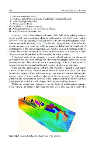
In order to create a three-dimensional model of the field, initial existing informa-
tion is loaded (well coordinates, altitudes, inclinometry, well logs). After loading
the source data and creating a working project, the structural-stratigraphic frame-
work of the model is created (Fig. 15.3). For this, using the data of the reference
seismic horizons as a trend, the wells are correlated beforehand (a breakdown of
the formations in the wells is recorded). As a result, a tectonic disturbance model is
created. The detailed correlation of the section is carried out on the basis of a series
of transverse and longitudinal profiles covering the entire structure.
A structural model of the reservoir is created with all tectonic formations and
discontinuations only after creating the structural-stratigraphic framework of the
reservoir horizons. This allows to obtain structural maps of the roof and bottom of
the reservoir and the external and internal contours of oil-bearing structure.
When studying sedimentation conditions, the principle of sequential stratigraphy
is taken into the account, which allows to predict the strata units order. This study
includes the sequence of the sedimentation process when the common chronostrati-
graphic system of process cycles is also taken into the account. The sedimentary
complexes are determined on the basis of the internal reservoir geometry and their
development in accordance with changes in the historic shelf environment.
Within the stratigraphic framework, on the basis of sedimentation patterns,
a thin “slicing” of stratas is performed for each layer. This leads to creation of a
Figure 15.3 Structural stratigraphic framework of the horizon.