
Page 377 - Soil and water contamination, 2nd edition
P. 377
364 Soil and Water Contamination
a
Arable land 6642 6642 6642
Afforested land
Other
Heath and rough grazing
50 50
5 km
b 0
Depth (m) 100
200
300
14 July 1978
c 48
Conductivity (μS cm -1 , 25 ¡C) 44
40
d 1.8
Chlorophyll (mg m -3 ) 1.6
12 October 1978 1.4
e
52
48
Conductivity -1 , 25 ¡C) (μS cm 44
40
36
f 1.4
Chlorophyll (mg m -3 ) 1.2
1.0
10 20 30
Distance (km)
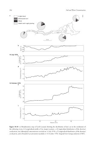
Figure 18.18 a) Morphometric map of Loch Lomond showing the distribution of land use in the catchments of
the inflowing rivers; b) Longitudinal profile of the deepest section; c, d) longitudinal distribution of the electrical
conductivity and chlorophyll concentration recorded on 14 July 1978; e, f) longitudinal distribution of the electrical
conductivity and chlorophyll concentration recorded on 12 October 1978. Adapted from George and Jones (1987).
10/1/2013 6:47:49 PM
Soil and Water.indd 376 10/1/2013 6:47:49 PM
Soil and Water.indd 376