
Page 31 - Sumatra Geology, Resources and Tectonic Evolution
P. 31
18 CHAPTER 3
6 ............. , ' ' o ~ I o -,
E .ELF :t 102 SOUT. SE , 108 E
-N(. {'~.,, _~ &7. ")~>o ? " ~ i i
" Lake . ~ ....................................................
{ "v.-<o "\ ~ . l ~. Natuna ,-~e i
SIN,;KEL . \ .~,. . ' i
? ~ 3 N
Nias'~ ~ .~.'V >'%..t>~" ;'. ',. " "
Plnl :...;. . .
ll,.~t,, le~"Xl, ~ ~ ] "2%.~.~, :*. ':g"" :~*'~'e/~, ) \K, ~!
4-. "~ ~<'t.:.:" : "',, ~"(!"~. " o"
9 "~ . ~,. ".'~{':..: ~:"" "'~,-ff Ban ,ka
,v,,~ ~ .... .22 "~ t ~ "-'-, : "':-:- . 9
.~-:. \\ % "'..' "-:'. -rV77~ ;-~ g ~2 ~ ' ~
~" ~":'".,::"': i ":f,. ''.~. " ..:'7"~. 0
"c';> ~a '~< "'~
~
~3~\~,,~ :: ..... "~'. "t., ........ ~4,.~.. " / SHELF
.~\~.Y )I6"K~ :: t:lllamallcs ~1~ ~ - " :': ,%~:':',."v-J
{ " .:." ,'~.1 : s
-t% tA>4-_~ ) )} ~"'~"-5 ~,t*~z-x~x - ~ ~ a.~,"'"'%,J .... ,J ..... "z
2' 30"N . ....................... ............... " .......................... .~ v .r
- : ~ ~ OCEAN < ~
imeu,ue
9(,"E 9630" I!
. . . . . . .
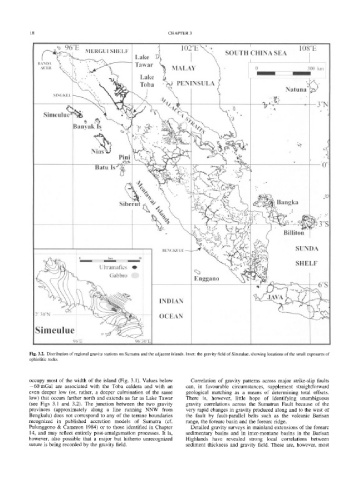
Fig. 3.2. Distribution of regional gravity stations on Sumatra and the adjacent islands. Inset: the gravity field of Simeulue, showing locations of the small exposures of
ophiolitic rocks.
occupy most of the width of the island (Fig. 3.1). Values below Correlation of gravity patterns across major strike-slip faults
-60 mGal are associated with the Toba caldera and with an can, in favourable circumstances, supplement straightforward
even deeper low (or, rather, a deeper culmination of the same geological matching as a means of determining total offsets.
low) that occurs farther north and extends as far as Lake Tawar There is, however, little hope of identifying unambiguous
(see Figs 3.1 and 3.2). The junction between the two gravity gravity correlations across the Sumatran Fault because of the
provinces (approximately along a line running NNW from very rapid changes in gravity produced along and to the west of
Bengkulu) does not correspond to any of the terrane boundaries the fault by fault-parallel belts such as the volcanic Barisan
recognized in published accretion models of Sumatra (cf. range, the forearc basin and the forearc ridge.
Pulunggono & Cameron 1984) or to those identified in Chapter Detailed gravity surveys in mainland extensions of the forearc
14, and may reflect entirely post-amalgamation processes. It is, sedimentary basins and in inter-montane basins in the Barisan
however, also possible that a major but hitherto unrecognized Highlands have revealed strong local correlations between
suture is being recorded by the gravity field. sediment thickness and gravity field. These are, however, most