Page 34 - Sumatra Geology, Resources and Tectonic Evolution
P. 34

GRAVITY FIELD                                             21


                                               A
                                                          S.I.O. RAMA 6  Line 58-59


                                                           Pleistocene - Recent


                   Banyak   Is,

                                                            Interpretation  simplified  after Matson &  Moore (1992)


                                           ill


             -b


             X\x"X\.,
                                                                            /.
                                                                         .././/"    I~
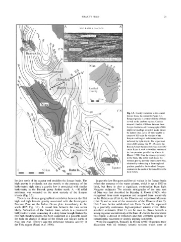
                                                                                            Fig. 3.5. Gravity variations in the central
                                                                                            forearc basin. In contrast to Figure 3.1,
                                                                                ///"        Bouguer gravity is contoured in the offshore
                                                                                            as well as the onshore regions. Contour
                                                                                            interval 10 mGal. Offshore data are from
                                                                                            Scripps Institution of Oceanography (SIO)
                                                                                            shipborne readings along the tracks shown
                                                                                            by dashed lines. Areas of water depths in
                                                                                            excess of 500 m in the vicinity of the
                                                                                            Banyak and Singkel sedimentary basins
                                                                                            indicated by light stipple. The upper inset
                                                                                            shows SIO seismic line 58-59  across the
                                                                                            Banyak forearc basin east of Nias, from SIO
                                                                                            cruise Rama 6, with a simplified version of
                                                                                 Pini       the interpretation provided by Matson &
                                ///"
                                                                                            Moore (1992). Note the strong asymmetry
                                                                                            in the basin. The lower inset shows the
                                 ///"       \                                               residual gravity anomaly over eastern Nias,
                                                                                            obtained by subtracting a linear regional
                                                                                 Equator
              0                50kin        '  ~   Batu  Is.                                gradient parallel to the trends of Bouguer
              ~ - T 7  ~ s  ~  ~2~l~I~E                                                     contours in the north of the island from the
                                                 98~                                        local values.

            lies just  north  of the  equator  and  straddles  the  forearc  basin.  The   In part  the  low Bouguer  and  free-air  values  in the  forearc  basin
            high  gravity  is  evidently  not  due  merely  to  the  presence  of  the   reflect  the  presence  of  the  water  column,  which  is  up  to  1500  m
            bathymetric  high,  since  a  gravity  low  is  associated  with  similar   thick,  but  there  is  also  a  significant  contribution  from  light
            bathymetry  in  the  Banyak  group  further  north.  A  -80  mGal   Neogene  sediments  The  seismic  stratigraphy  of  the  area  east
            minimum  was  recorded  on  the  most  easterly  of  the  Banyak   of  Nias  was  first  described  by  Beaudry  &  Moore  (1985),  who
            islands  (Fig.  3.5).                                   recognized  three  main  sequences  and  assigned  these  tentatively
              There  is  an  obvious  geographical  correlation  between  the  Pini   to  the  Pleistocene  (Unit  4),  the  Pliocene  and  uppermost  Miocene
            high  and  high  free-air  gravity  associated  with  the  Investigator   (Unit  3)  and  to  most  of  the  remainder  of  the  Miocene  (Unit  2).
            Fracture  Zone  on  the  Indian  Ocean  plate  immediately  to  the   Unit  2  was  further  subdivided  into  Units  2a  and  2b,  separated
            south  (IFZ;  Fig.  3.1).  A  causal  link  between  the  two  seems   by  a  generally  continuous,  high-amplitude  seismic  event.  Older
            likely.  Subduction  of  the  fracture  zone,  which  is  a  prominent   stratified  sediments  (Unit  1)  can  be  seen  in  places  beneath  a
            bathymetric  feature  consisting  of a  deep  linear trough  flanked  by   strong regional unconformity at the base of Unit 2a, but elsewhere
            two  high  standing  ridges,  has  been  suggested  as  a  possible  cause   this  region  is  devoid  of  reflectors  and  may  comprise  igneous  or
            for  both  the  change  in  strike  of  the  trench  and  forearc  north  of   metamorphic  basement  or  steeply  dipping  sediments.
            Nias  (the  Nias  'elbow')  and  the  enhanced  volcanic  activity  in   With  one  exception,  Beaudry  &  Moore  (1985)  illustrated  their
            the  Toba  region  (Fauzi  et  al.  1996).              discussion  with  oil  industry  seismic  sections  which  were  of
   29   30   31   32   33   34   35   36   37   38   39