
Page 33 - Sumatra Geology, Resources and Tectonic Evolution
P. 33
20 CHAPTER 3
i
- 0" 30'S
9
~Bohiam"
o
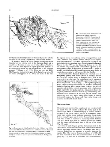
Fig. 3.3. Bouguer gravity and main structural
controls of the Ombilin Basin, after
Situmorang et al. (1991). Contour interval
10 mGal (thick contours) and 2 mGal (thin
contours). Stipple indicates closed lows.
Steep gradients in the west of the area are
associated with the margins of the Late
Neogene Singkarak pull-apart basin. Weaker,
but still well defined anomalies are associated
with the Palaeogene basin and testify to the
complexity of the basement architecture. See
100 ~ 45'E IOF'E
i i Figure 3.1 for location.
developed isostatic compensation of the older depocentre or to the the regional survey provided only patchy coverage (Sobari et al.
Neogene section having a significantly lower average density. 1992). However, very detailed onshore surveys for oil explora-
The Bengkulu Basin (Fig. 3.4) is roughly the same age as the tion (Yulihanto et al. 1995) have confirmed the division of the
Ombilin but lies entirely west of the Sumatran Fault and at main basin into two structural lows. These features (the Pagarjati
much lower elevations. A large part of it lies offshore. Tradition- Graben in the NW and the Kedurang Graben in the SE)
ally, it too has been regarded as a pull-apart basin generated in are oriented very roughly north-south and are separated by the
a transtensional regime and this interpretation is still generally Masmambang High. Within these broad divisions, a series of
accepted (Yulihanto et al. 1995). There are very few BGS/ roughly equi-dimensional highs and lows cover areas similar in
GRDC gravity stations in the part of the basin lying to the SE size to those occupied by sub-basins within the Ombilin.
of Manna (Nainggolan et aL 1992) and even in the west A peculiarity of the Bengkulu Basin is the very high level of
background gravity field, which results in strongly positive
(>+40 mGal) absolute levels of Bouguer gravity even in the
centres of the gravity lows. The basinal area overall appears on
regional maps as a gravity high and Bouguer levels on the horst
102' 3{}'E 103E blocks may exceed -t-80 mGal (Fig. 3.4). The high fields probably
reflect crustal thinning beneath both the Bengkulu sedimentary
basin itself and the forearc marine basin. However, the offshore
3 30'S
PAGARJATI extension of the high, which is associated with a bathymetric
bulge, is probably also partly due to the replacement of seawater
by young sediments and to the lack of any corresponding com-
30 pensatory local subsidence of the crust into the mantle. Such
Bengkulu
patterns are seen over many young deltas formed at passive
continental margins, the Congo and Niger deltas being good
examples (Sandwell & Smith 1997).
4S
MASMAMBANG
The forearc basin
The northeastern margin of the deep free-air low associated with
the trench west of Sumatra includes the frontal part of the
KEDURANG
forearc ridge, which is composed largely of accreted material.
Manta The crest of the forearc ridge is marked by a prominent asym-
metric high, with the steeper gradients towards the forearc basin.
In most cases, Bouguer gravity on the forearc islands decreases
from west to east in response to increasing crustal thickness
(Fig. 3.5), but on Nias there is a residual gravity high centred
over the young uplifted coastal plain in the east of the island
0_. .......... 2 0 k,,
(Fig. 3.5, inset).
Low free-air and Bouguer gravity characterize most of the
Fig. 3.4. Bouguer gravity of the Bengkulu Basin, after Yulihanto et al. (1991). forearc basin, with minimum values even lower than the free-air
Contour interval 5 mGal (thick contours) and 1 mGal (thin contours). The overall minima associated with the trench. The forearc basin low is,
high level of Bouguer gravity is probably largely a consequence of crustal however, divided into two segments by a gravity high near the
thinning beneath the forearc basin. Local closed lows, indicated by stipple, equator (Fig. 3.1), where a Bouguer maximum of +100 mGal
identify the locations of separate depocentres within the basin. See Figure 3.1 has been recorded on Pini, the easternmost island in the Batu
for location. group (Fig. 3.5). Pini has an anomalous east-west orientation,