
Page 38 - Sumatra Geology, Resources and Tectonic Evolution
P. 38
PRE-TERTIARY STRATIGRAPHY 25
Bohorok Formation. The Bohorok Formation is defined from its
CENOZOIC
type locality in the Bohorok River on the GRDC 1:250 000
Medan Sheet, about 65 km to the west of Medan (Cameron
CRETACEOUS et al. 1982a) (Fig. 4.3). Good exposures of this formation occur
for a distance of 100 m in the river section at Bukit Lawang,
near the Orang Utan Sanctuary and over 50 m in the Bekail
JURASSIC River, some 7 km to the south. No base is seen to the formation
and downstream the mudstones are faulted either against the
Permo-Triassic Batumilmil Limestone Formation, or the Tertiary
Bruksah and Bampo Formations. The Bohorok Formation has
TRIASSIC
been mapped along the eastern side of the Barisan Mountains
from near Langsa in the north to Lake Toba in the south
(Fig. 4.3). Even further south, comparable lithologies correlated
PERMIAN
with the Bohorok Formation, are found in the Tigapuluh
Mountains, between Rengat and Jambi and are described below
as the Tigapuluh Group, and similar rocks also occur in the
CARBONIFEROUS Toboali District in the southern part of Bangka Island (Fig. 4.2).
The typical lithology of the Bohorok Formation is an unbedded
DEVONIAN 'pebbly mudstone'; a poorly sorted breccia or conglomerate
composed of angular to subangular rock fragments, generally
LOWER
PALAEOZOIC 0.1-2.0 cm in size, but ranging up to 10cm and even 75-
80 cm in east Aceh, and in the northeastern part of the Padangsi-
PRECAMBRIAN dempuan Sheet (Aspden et al. 1982b). The rock fragments
BASEMENT
are enclosed in a fine-grained matrix of dark grey or dark brown
siltstone or mudstone. Pebbles include vein quartz, slate, chlorite
schist, phyllite, greenish calcsilicate rocks, limestone, marble,
quartzose arenites, quartzite, more rarely mica-schist and grani-
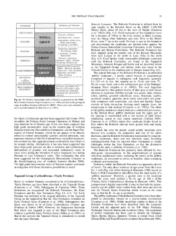
Fig. 4.1. Pre-Tertiary stratigraphic units in Sumatra as proposed by the DMR/
BGS Northern Sumatra Project (Cameron et al. 1980) and used on the geological toid, sometimes with tourmaline, rare chert and rhyolite. Single
maps of northern Sumatra published by GRDC. These units were extended to crystals of fresh microcline, forming small angular clasts, are
cover southern Sumatra by McCourt et al. (1993). conspicuous in thin sections (Cameron et al. 1982a). The clasts
in the pebbly mudstones clearly indicate a continental provenance.
In the Berkail River, pebbly mudstone near the upper part of
the outcrop is interbedded with a few metres of light brown
for which a Cretaceous age had been suggested (De Coster 1974) weathering, coarse to very coarse sandstone (Tiltman 1985).
resembles the Silurian Kuala Lumpur Limestone in Malaya and Cameron et al. (1982a) report that sandstone blocks found as
may therefore be of Silurian age. It has also been supposed that float within the Bohorok outcrop show graded beds and slump
high grade metamorphic rocks in the western part of northern structures.
Sumatra within the Alas and Kluet Formations, and the Ngaol For- Towards the west the poorly sorted pebbly mudstone units
mation of Central Sumatra, which do not appear to be directly become less common, the proportion and size of the clasts
related to contact metamorphic aureoles around intrusions, may decreases, and the Bohorok Formation is represented by conglom-
represent outcrops of this Pre-Carboniferous crystalline basement, erates, sandstones, slates and rare limestone units, becoming
but nowhere has this supposition been confirmed by fossil finds or indistinguishable from the adjacent Kluet Formation or similar
by isotopic dating. Alternatively it has also been suggested that lithologies within the Alas Formation, so that the distinction
these high grade gneisses are due to intrusion and synkinematic between the units is arbitrary (Cameron et al. 1980).
deformation of granites and associated sedimentary rocks in The Bohorok Formation has generally been affected by low,
shear zones during the formation of active magmatic arcs during slate-grade, metamorphism. In the neighbourhood of igneous
Permian to Late Cretaceous times. This explanation has also intrusions argillaceous rocks, including the matrix of the pebbly
been suggested for the Gunungkasih Metamorphic Complex in mudstones, are converted to schists or hornfels, often containing
the Bandarlampung area of southern Sumatra (Barber 2000). cordierite and tourmaline.
The high grade metamorphic rocks of Sumatra require systematic Sediments within the Bohorok Formation are apparently devoid
investigation with these alternative possibilities in mind. of fossils. The only direct evidence of age comes from the Cucut
No. 1 well (Fig. 4.4) where Koning & Darmono (1984) report an
Early to Mid-Carboniferous microflora from the mud matrix of a
Tapanuli Group (Carboniferous- ?Early Permian) 'pebbly mudstone'. However, a granite clast in the mudstone
from the same well yielded a K-Ar age of 348 + 10Ma
Rocks in northern Sumatra considered to be of Carboniferous- (Vis6an, Early Carboniferous) (Koning & Darmono 1984). This
?Early Permian age have been classified as the Tapanuli Group juxtaposition is highly improbable. It may be that both the palyno-
(Cameron et al. 1980; Pulunggono & Cameron 1984). Three morphs and the pebble were eroded from older units and derived
formations are recognized: the Bohorok Formation, the Kluet into the Triassic Kualu Formation which occurs in the same
Formation and the Alas Formation (Figs 4.1-4.3). The Early area, or that the K-Ar age is unreliable.
Permian was included in the original definition of the Tapanuli The pebbly mudstones of the Bohorok Formation have been inter-
Group on the supposition that the Alas Formation contained an preted as diamictites formed in a glacio-marine environment
Early Permian fauna (Cameron et al. 1980). Subsequently this (Cameron et al. 1980). Pebbly mudstones similar to those of the
fauna was shown to be of Early Carboniferous (Vis~an) age Bohorok Formation have been described form the Langkawi
(Fontaine & Gafoer 1989). However, the Pangururan Bryozoan Islands and the adjacent parts of the NW Malay Peninsula,
Bed which was mapped as part of the Kluet Formation also Peninsular Thailand, Burma and southwest China. The occurrence
contains a probable Early Permian fauna (Aldiss et al. 1983), so of pebbly mudstones has been used to identify the Sibumasu
that in this account the Tapanuli Group is considered to extend (Siam, B___uurma, Malaya, Sumatra) Terrane, a crustal block which
into the Early Permian. extends all the way from Sumatra to southern China (Metcalfe 1984).