
Page 260 - The Geological Interpretation of Well Logs
P. 260
- THE GEOLOGICAL INTERPRETATION OF WELL LOGS -
an - Ss
lo ’ 2 20 jee “
4
‘
|
f
b—~—1- TS/SB~J —_—_—_—-. = us” ————}—— _
anon] 5 4
“ 1
“>
2 ‘ te
o 1
S| & I
=
wn ow 9 = ‘ @ "e 70 24d. ” Bald
3
ial pz ‘ > 5 5 a
Z| & Oo
Oo} I 7 =. Zé
a 3 900% L ot 4 s
o
Zloa ee \
~~? ——}- :
{ 4
é
oc ¢ t - > =
Fl 2 Q ra
5 ; fr
» ®
\
— ae go es
.
c
mk ann C
~
—<
pm $8 | ote \
nom e \
= °
= I | >
| 2 ! 8
x i & ' 5 -/%
i)
\ } 2 x
a 4 3% 5 oO
: ©
‘
_ 1000e0] L —_ = > —h — 4
j
s. Pa
“7 ¢
1
~
9 ' 7 m4 x
2 1 ? wo
a - é ' ? $ z2
z| a 1 a | 9
re < i to Q _ ls fe
wu
wy « — — SS —
5 © ” oc
=| oO a py a ‘ ! 2 } . — | ae 4
\
PN
+]
"0h
=
a
}
i
r
?
——
2
}
\
;
2 5
< ‘
e
3
;
<
t
Q
¢
—{-— i —
J
mes
i L
oe
__>
_
__|
—
;
ae
WELL B
we
WELL A — , 2S | ee fy,
2.5km
0 4
—— |
———
100
[_
200 ~-ee_—_—____-___ —=3 === ——=
hm oo
en ah
dr
5 7 ° 1 2Km
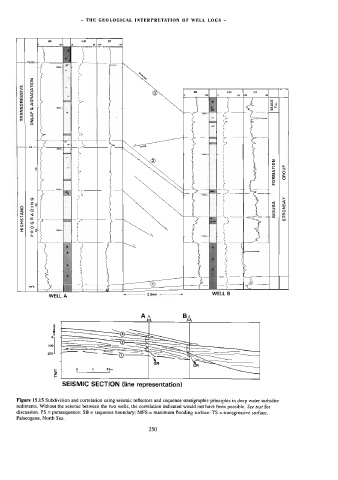
SEISMIC SECTION (line representation)
Figure 15.15 Subdivision and correlation using seismic reflectors and sequence stratigraphic principles in deep water turbidite
sediments. Without the seismic between the two wells, the correlation indicated would not have been possible. See text for
discussion. PS = parasequence: SB = sequence boundary: MFS = maximum flooding surface: TS = wansgressive surface.
Palaeogene, North Sea.
250