
Page 331 - Volcano and Geothermal Tourism
P. 331
Volcano Tourism in the New Kanawinka Global Geopark of Victoria and SE South Australia 307
of interest include the Western Plains Grassland, houses and fish and eel traps, and also post-contact
Lake Condah and the Floating Islands, and coastal basalt stone walls and historic buildings
areas such as the Port Campbell National Park and (Figure 20.3). An active art and history movement
the Bay of Islands Coastal Park, and Bridgewater is part of the cultural heritage of the local people.
Bay. For these reasons, the area was recognized as
the Kanawinka Global Geopark in June 2008, and
Nomination of the volcanic in the following 12 months the geotourism of the
areas of western Victoria and area has been under development, with programmes
south-east South Australia as to assemble further information, and develop new
material for use by geotourists, geotourism
the Kanawinka Global Geopark operators and local government bodies. The
Australia’s first geopark is on the broad Western accuracy and usefulness of the volcanic information
Plains of Victoria and the adjacent part of south- must be based on the extensive past scientific
eastern South Australia, with some 100 well- studies of the volcanoes and other geological and
studied volcanoes ranging in age from five million cultural features of the area, but will also make use
years to just a few thousand years. Within the area of the new approach of the ‘Geomorphosites and
of the new Kanawinka Geopark are many Volcanism’ chapter in Geomorphosites (Joyce, 2009).
important volcanic features including lava caves of The Kanawinka Geopark of
international significance, open volcanic vents,
major tumuli groups, and springs and waterfalls. south-east Australia as an
Coastal features include limestone cliffs, calcareous example of volcano tourism
dunes, basalt headlands and cliffs, drowned lava
flows and a large offshore volcanic island. Extensive The young volcanic areas of the Western Plains of
karst plains and limestone caves are found in the Victoria and adjacent South Australia have more
west, and in the east Quaternary, often saline, lake/ than 100 small scoria cones, maars and lava shields,
lunette systems are major Ramsar sites. Cultural built up by Strombolian/Hawaiian eruptions over
features include indigenous heritage such as stone the past five million years. Fluid basalt flows spread
laterally around vents, often for many tens of
kilometres down river valleys. Where the lava flows
blocked drainage, lakes and swamps were formed.
Phreatic eruptions deposited ash and left deep maar
craters, often now with lakes. The youngest dated
eruption is that of Mt Gambier in south-eastern
South Australia, at 4000–4300BC. The highest
volcano is Mt Elephant, near the centre of the plains.
It rises nearly 200m above the plains to an elevation
above sea level of 393m, with a crater 90m deep, and
is similar in size to Mt Kooroocheang, the highest
volcano in the Western Uplands. First identified as a
volcanic region nearly 170 years ago the Newer
Volcanic Province of south-eastern Australia is now
one of the best studied of the world’s many young
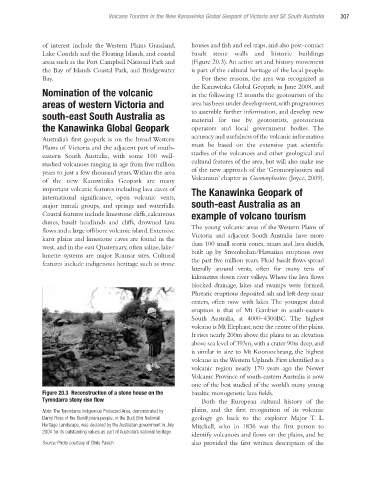
Figure 20.3 Reconstruction of a stone house on the basaltic monogenetic lava fields.
Tyrendarra stony rise flow Both the European cultural history of the
Note: The Tyrendarra Indigenous Protected Area, demonstrated by plains, and the first recognition of its volcanic
Darryl Rose of the Gunditjmara people, in the Budj Bim National geology go back to the explorer Major T. L.
Heritage Landscape, was declared by the Australian government in July Mitchell, who in 1836 was the first person to
2004 for its outstanding values as part of Australia’s national heritage.
identify volcanoes and flows on the plains, and he
Source: Photo courtesy of Chris Pavich also provided the first written description of the
Ch20.indd 307 4/7/2010 12:21:53 PM