
Page 333 - Volcano and Geothermal Tourism
P. 333
Volcano Tourism in the New Kanawinka Global Geopark of Victoria and SE South Australia 309
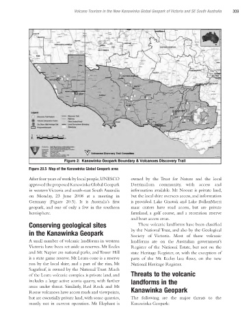
Figure 20.5 Map of the Kanawinka Global Geopark area
After four years of work by local people, UNESCO owned by the Trust for Nature and the local
approved the proposed Kanawinka Global Geopark Derrinallum community, with access and
in western Victoria and south-east South Australia information available. Mt Noorat is private land,
on Monday, 23 June 2008 at a meeting in but the local shire oversees access, and information
Germany (Figure 20.5). It is Australia’s first is provided. Lake Gnotuk and Lake BullenMerri
geopark, and one of only a few in the southern maar craters have road access, but are private
hemisphere. farmland, a golf course, and a recreation reserve
and boat access areas.
Conserving geological sites These volcanic landforms have been classified
in the Kanawinka Geopark by the National Trust, and also by the Geological
Society of Victoria. Most of these volcanic
A small number of volcanic landforms in western landforms are on the Australian government’s
Victoria have been set aside as reserves. Mt Eccles Register of the National Estate, but not on the
and Mt Napier are national parks, and Tower Hill state Heritage Register, or, with the exception of
is a state game reserve. Mt Leura cone is a reserve parts of the Mt Eccles lava flows, on the new
run by the local shire, and a part of the rim, Mt National Heritage Register.
Sugarloaf, is owned by the National Trust. Much
of the Leura volcanic complex is private land, and Threats to the volcanic
includes a large active scoria quarry, with further landforms in the
areas under threat. Similarly, Red Rock and Mt
Rouse volcanoes have access roads and viewpoints, Kanawinka Geopark
but are essentially private land, with some quarries, The following are the major threats to the
mostly not in current operation. Mt Elephant is Kanawinka Geopark:
Ch20.indd 309 4/7/2010 12:21:54 PM