
Page 292 - Water Loss Control
P. 292
Contr olling Real Losses in the Field—Pr oactive Leak Detection 261
16.2 Mapping
The first thing which must be done when considering tackling real losses in the field is
to ensure that the maps and plans of the system and its components are as accurate and
current as possible. The media on which water company plans are kept vary widely,
from distribution systems with the latest geographical information system (GIS) soft-
ware, to systems with up-to-date paper plans, to systems with an up-to-date picture in
someone’s head, to systems in which no one has any idea where anything is! Obviously,
the cost of updating such systems will vary greatly.
Systems with good plans and organized, structured background data tend to be more
efficient, as the managers responsible for day-to-day decisions have tools at their fingertips
with which to make decisions about the performance of their organization. Systems with
very little background data find it very hard to set a realistic objective for leakage reduction
performance. Even after launching a project to improve performance, these systems find it
hard to justify the results, as they do not have reliable baselines from which to measure.
Water utilities in this position should consider putting the data in order and improved map-
ping in place prior to beginning a structured leakage control program.
GIS software is a highly effective tool for managing system plans and provides a
very user-friendly graphical interface. GIS also brings other benefits, as it can integrate
with other management information systems such as financial and billing databases,
telemetry and SCADA systems, and work order management systems. A GIS can also
be linked with a hydraulic model, which is a decision-making tool used by many water
utilities. As the GIS is linked with the model, there is less need for costly model
updates—the distribution system asset data in the model is automatically updated as
edits are conducted in the GIS.
Global positioning systems (GPS) are being used by many water utilities to auto-
matically register or locate system components and major features within the system
through the use of satellite positioning. GPS coordinates are often used within the GIS
environment. While GPS sounds like it might be complex and difficult to operate, it is
very user-friendly. GPS data can be downloaded automatically into most GIS databases.
The cost of GPS systems varies widely with the resolution and capabilities required, but
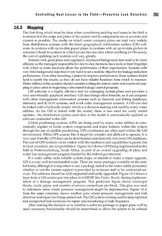
in most countries, are not prohibitive. Figure 16.2 shows GPS being implemented in the
field in Pietermaritzburg, South Africa, as part of an overall upgrading of plans and
water loss management program funded by the federal government.
If a water utility lacks reliable system maps, or intends to make a major upgrade,
GIS is a very well-recommended route. There are many packages available on the mar-
ket today, although it is important to use a package suited to the water utility personnel,
whether or not the system support is provided by in-house staff or by contracted ser-
vices. The software should be well supported and easily upgraded. Figure 16.3 shows a
layer from a GIS system put into place in SABESP, São Paulo, Brazil, during implemen-
tation of a leakage management program. This particular figure shows municipal
blocks, roads, pipes, and number of service connections per block. This plan was used
to determine areas where pressure management might be implemented. Figure 16.4,
from the same company, shows another zone where pressure management and leak
detection and repair are being carried out. The GIS system is being used to map reported
and unreported leak locations for repair and monitoring of leak frequency.
After making the decision as to whether a software package or paper plans will be
used, necessary functionality should be determined to allow the system to be utilized