
Page 78 - Water and wastewater engineering
P. 78
GENERAL WATER SUPPLY DESIGN CONSIDERATIONS 2-21
Unconfined Aquifer. The components of the evaluation of the aquifer as a water supply are:
(1) depth of the aquifer, (2) annual precipitation and resultant aquifer recharge, and (3) draw-
down for sustained pumping at the design rate of demand.
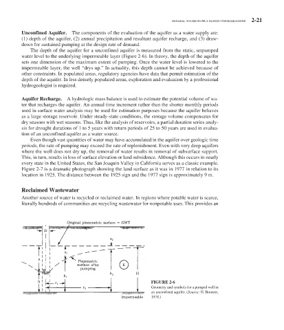
The depth of the aquifer for a unconfined aquifer is measured from the static, unpumped
water level to the underlying impermeable layer ( Figure 2-6 ). In theory, the depth of the aquifer
sets one dimension of the maximum extent of pumping. Once the water level is lowered to the
impermeable layer, the well “drys up.” In actuality, this depth cannot be achieved because of
other constraints. In populated areas, regulatory agencies have data that permit estimation of the
depth of the aquifer. In less densely populated areas, exploration and evaluation by a professional
hydrogeologist is required.
Aquifer Recharge. A hydrologic mass balance is used to estimate the potential volume of wa-
ter that recharges the aquifer. An annual time increment rather than the shorter monthly periods
used in surface water analysis may be used for estimation purposes because the aquifer behaves
as a large storage reservoir. Under steady-state conditions, the storage volume compensates for
dry seasons with wet seasons. Thus, like the analysis of reservoirs, a partial duration series analy-
sis for drought durations of 1 to 5 years with return periods of 25 to 50 years are used in evalua-
tion of an unconfined aquifer as a water source.
Even though vast quantities of water may have accumulated in the aquifer over geologic time
periods, the rate of pumping may exceed the rate of replenishment. Even with very deep aquifers
where the well does not dry up, the removal of water results in removal of subsurface support.
This, in turn, results in loss of surface elevation or land subsidence. Although this occurs in nearly
every state in the United States, the San Joaquin Valley in California serves as a classic example.
Figure 2-7 is a dramatic photograph showing the land surface as it was in 1977 in relation to its
location in 1925. The distance between the 1925 sign and the 1977 sign is approximately 9 m.
Reclaimed Wastewater
Another source of water is recycled or reclaimed water. In regions where potable water is scarce,
literally hundreds of communities are recycling wastewater for nonpotable uses. This provides an
FIGURE 2-6
Geometry and symbols for a pumped well in
an unconfined aquifer. (Source: H. Bouwer,
1978.)