
Page 184 - Well Logging and Formation Evaluation
P. 184
174 Well Logging and Formation Evaluation
any magnetic anomalies, the Earth’s field must first be subtracted from
the magnetometer readings. The basic procedure for locating the posi-
tion of a target well, using a three-axis magnetometer combined with
accelerometers, is therefore as follows:
1. Using the accelerometer data, the raw magnetometer readings are con-
verted to the highside reference system.
2. The Earth’s magnetic field is derived in the highside reference system
(E hs , E hsr , E ax ) as a function of depth in the survey well. Note that while
the Earth’s field may be constant, the components in the survey well
will vary if the well’s inclination and azimuth vary.
3. The Earth’s components are subtracted from the magnetometer com-
ponents to derive the components of the disturbance (denoted as F).
Hence:
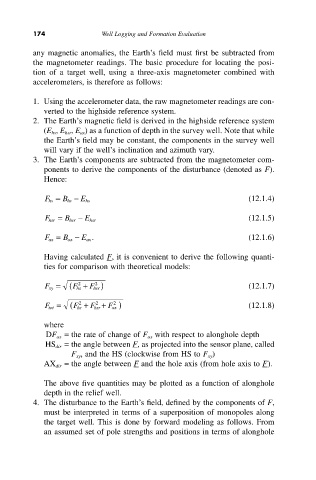
F hs = B hs - E hs (12.1.4)
F hsr = B hsr - E hsr (12.1.5)
F ax = B ax - E ax . (12.1.6)
Having calculated F, it is convenient to derive the following quanti-
ties for comparison with theoretical models:
2
F xy = ( F hs + F hsr ) (12.1.7)
2
2
F tot = ( F hs + F hsr + F ax ) (12.1.8)
2
2
where
DF ax = the rate of change of F ax with respect to alonghole depth
HS dir = the angle between F, as projected into the sensor plane, called
F xy , and the HS (clockwise from HS to F xy )
AX dir = the angle between F and the hole axis (from hole axis to F).
The above five quantities may be plotted as a function of alonghole
depth in the relief well.
4. The disturbance to the Earth’s field, defined by the components of F,
must be interpreted in terms of a superposition of monopoles along
the target well. This is done by forward modeling as follows. From
an assumed set of pole strengths and positions in terms of alonghole