
Page 291 - Whole Earth Geophysics An Introductory Textbook For Geologists And Geophysicists
P. 291
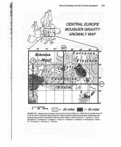
273                                                                                       13°

      Expressions      EUROPE   GRAVITY   MAP                                                mGal   60   1994).  Gravity  profiles  along   northwestern  and   Czech   C=   Serbia;   =


      Gravity                                                                                <-    Austria;   =   Romania;  Se   =


      their                    ANOMALY                                                               R  Poland:
      and             CENTRAL   BOUGUER                                                          regions  in  southern  and  extreme   =   P
      Settings                                                                                 mGal   Moldava;


      Tectonic                                                                               |>-20  Bouguer gravity  anomaly  map  of central  Europe  (Lillie  et  al.,   Blank  portions  of  map  lacked  sufficient  station  density  to  draw  contours.  A   =  [taly;  M   [  =


                                                                                                 Figs.  8.50  and  8.51.   in  N  shown   Hungary:   =  Germany;  H   Ukraine.   =  Slovenia;  U


                                                                                                8.49   E,  and  47°   G =   =  Slovakia;  Sv
                                                                                                FIGURE   E,  20°   southeastern   Republic;   =
                                                                                                      SI


                   Age  ep  Sey   cette   ‘aE


          seismic   Bouguer   borehole   3.10).   inter-   that   inside   on   at   in   the   of   root   Canada   by   by   of   conti-   island   Peninsula   and   the   split   gravity   min-   early   repre-   advanced   shallow   subsur-   in   anom-

          from   7)   and   (Fig.   cross-sectional   and   1.8),   (back   anomalies   correction   interpreted   mest   crustal   States,  caused   coast   thick   8.35).   or   by  modified   highs   the   of  seaward   the   low  broad   mid-ocean ridge   Bouguer   low-amplitude   during   an   low   more   and   earlier   from
          boundary   anomaly;  air  gravity   surface  sample   velocities  seismic   result’  in   Fig.  constraints,   America  North   Bouguer   and   Bouguer   the   can  most   be   comprising   (Fig.  8.41).   and  topography   western   to  Mexico   Province.  caused  Range   United   billion-year-old   the   off   east   transition   from   8.34,   (Figs.   (continental   although   8.39).  At  Alaska   the   accentuate   occurs   in   arc  Antilles   a  displays   a  across


          lithosphere/asthenosphere   6)  free   from   come   on  based   likely  more   (first  order   of   map   sea   at   because   evident;   are   continental  craton,   States   the   high   from  western   Basin   and   central   the   1.1  failed,   shelf  edge   the   the   margin  passive   thicker   from   zones,   Fig.   side,   lithosphere   bulge  flexural   high   Lesser   the   of  Mexico.   coast   Iceland   of   air  anomalies   evident   a   1)  include:   on


      4     (Fig.  7.34);   densities   approximations   would   reality   anomaly   anomalies   air   shoreline,   the   features   8.48.   the   United   the   with  coincident   the   over   (Figs.  8.42,  8.43a).   through   the  along   near   representing   the   of   transitions   at  subduction   left   (see   rigid   of  a   a   in  observed   Pacific   the   south   free   of   features   8.49)   “keel”   Carpathians   eastern   8.50c);   (Fig.   supports   from   the   in

      Isostasy   the   methods   on   data   geological   gravity   free   at   prominent   in   Fig.   over   and   are  Mountains,  extending   occurs   runs   high   crust   the   (Fig.  8.43c)   prominent   are   States,   crust   occur  along   crust   isostasy   arc,  effects   anomaly,  and   are   along   segment   Prominent   Europe   (Fig.   downwarped   the   in   the   (Fig.   Basin   partially   resulting   be  studied   isostasy.

      and   depths  to   Constraints   as   these   of   isostasy.   The   presents   correspond   model   occur   of  Canada   values   low   gravity   into   effects   United   oceanic   (oceanic)   local   island   air   effects   and   Ridge  high,  characteristic   a   collision   beneath   collision   Pannonian   Isostasy   strength   anomalies   can   Airy
      Gravity   4.19);5)   time/tomography   well   as   all   of   honor   state   of   America   book)   Several   isostatic   values   parts   Rocky  (Figs.  4.16,  8.38,  8.47).   Bouguer   asthenosphere   intruded   rift   edge   the   and   thinner   also   thinner   from   free   Similar   region,   Mid-Atlantic   8.45;  8.46).   Europe   of  central   with   root   the   Local   plate   (Fig.  8.24)   simple


          to   anomaly.   that   this   anomalies   zero.   Bouguer   prominent   Keweenawan   air   to   effects   Aleutian   the   of   central   associated   continental   crustal   continental   beneath   Gravity   by
      8               the   North   is   the   Near-zero   eastern   the   broad   shallow   gabbro   Canada   nental   Edge   to   deviations   trench.   Caribbean   a   Central   map   from
     Chapter   (Figs.  4.16   delay   gravity   measurements,   Incorporation   pretations   consider   of   cover   land.  The   level   sea   terms   of   1   2.   Low   of   A   3.   +  A   wo  Free   6.   arc)   and   lows   The   7.   by   (Figs.   anomaly   imum   of   stage   a  senting   of   Stage   mantle   Lithospheric   loads.   face   chapter   this   caused  alies


     272                                                                                              Deviations


                                                                                    |   i   !  |  i