
Page 142 - Fluid Power Engineering
P. 142
W ind Resource Assessment 119
provide drawing tools to mark areas of different roughness.
Within a 5-km radius, detailed roughness classes should be
manually specified and coarser roughness may be specified
between 5 and 20 km radius. Very coarse-level roughness
data is available online from satellite-based land cover and
land use data. National Aeronautics and Space Administra-
tion (NASA) Modis satellite and global land cover character-
istics (GLCC ) database are two sources. The Modis roughness
data is an indication of vegetation and water bodies only and
does not account for roughness because of residential com-
munities, towns, and cities.
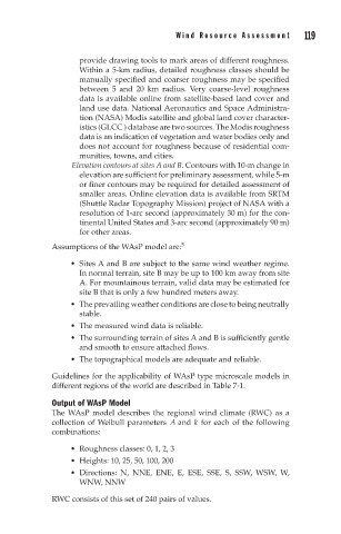
Elevation contours at sites A and B. Contours with 10-m change in
elevation are sufficient for preliminary assessment, while 5-m
or finer contours may be required for detailed assessment of
smaller areas. Online elevation data is available from SRTM
(Shuttle Radar Topography Mission) project of NASA with a
resolution of 1-arc second (approximately 30 m) for the con-
tinental United States and 3-arc second (approximately 90 m)
for other areas.
Assumptions of the WAsP model are: 5
Sites A and B are subject to the same wind weather regime.
In normal terrain, site B may be up to 100 km away from site
A. For mountainous terrain, valid data may be estimated for
site B that is only a few hundred meters away.
The prevailing weather conditions are close to being neutrally
stable.
The measured wind data is reliable.
The surrounding terrain of sites A and B is sufficiently gentle
and smooth to ensure attached flows.
The topographical models are adequate and reliable.
Guidelines for the applicability of WAsP type microscale models in
different regions of the world are described in Table 7-1.
Output of WAsP Model
The WAsP model describes the regional wind climate (RWC) as a
collection of Weibull parameters A and k for each of the following
combinations:
Roughness classes: 0, 1, 2, 3
Heights: 10, 25, 50, 100, 200
Directions: N, NNE, ENE, E, ESE, SSE, S, SSW, WSW, W,
WNW, NNW
RWC consists of this set of 240 pairs of values.