
Page 147 - Fluid Power Engineering
P. 147
W ind Resource Assessment 123
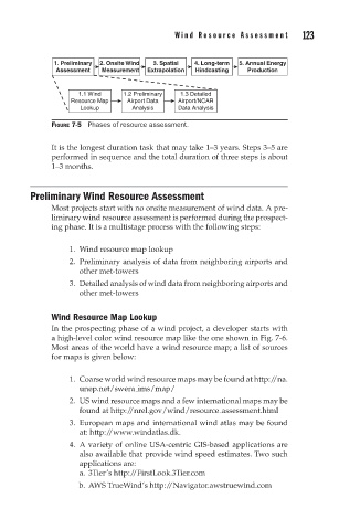
1. Preliminary 2. Onsite Wind 3. Spatial 4. Long-term 5. Annual Energy
Assessment Measurement Extrapolation Hindcasting Production
1.1 Wind 1.2 Preliminary 1.3 Detailed
Resource Map Airport Data Airport/NCAR
Lookup Analysis Data Analysis
FIGURE 7-5 Phases of resource assessment.
It is the longest duration task that may take 1–3 years. Steps 3–5 are
performed in sequence and the total duration of three steps is about
1–3 months.
Preliminary Wind Resource Assessment
Most projects start with no onsite measurement of wind data. A pre-
liminary wind resource assessment is performed during the prospect-
ing phase. It is a multistage process with the following steps:
1. Wind resource map lookup
2. Preliminary analysis of data from neighboring airports and
other met-towers
3. Detailed analysis of wind data from neighboring airports and
other met-towers
Wind Resource Map Lookup
In the prospecting phase of a wind project, a developer starts with
a high-level color wind resource map like the one shown in Fig. 7-6.
Most areas of the world have a wind resource map; a list of sources
for maps is given below:
1. Coarse world wind resource maps may be found at http://na.
unep.net/swera ims/map/
2. US wind resource maps and a few international maps may be
found at http://nrel.gov/wind/resource assessment.html
3. European maps and international wind atlas may be found
at: http://www.windatlas.dk.
4. A variety of online USA-centric GIS-based applications are
also available that provide wind speed estimates. Two such
applications are:
a. 3Tier’s http://FirstLook.3Tier.com
b. AWS TrueWind’s http://Navigator.awstruewind.com