
Page 165 - Advances In Productive, Safe, and Responsible Coal Mining
P. 165
Communication and tracking system performance 147
8.4.2 Measurement of tracking system variations when in motion
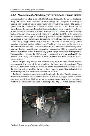
Measurements were taken using a SkyMark Survey Buggy. The device is a dead reck-
oning tool, which, when taken to a location underground, is capable of tracking its
location and recording various sensor data with accurate time stamps. The tracking
system does not communicate a device’s location with the tracked device, but the
tracked device locations are logged at the main tracking system computer. The buggy
is used to calculate the GTP of a set of handsets. Fig. 8.33 shows the general config-
uration of the cart while being towed. Radios are rotated around to be as far away from
the tow vehicle and as high in the mine as possible without hitting the roof. Handsets
are arranged in two orientations with four held vertically and two held horizontally.
The survey buggy records a single time and a location, while the tracking system
records a calculated location and two times. Tracking system times are the time that a
tracked device entered into a state or location and the last time it reported being at that
location. Handsets report the communication infrastructure RSSI at a predetermined
interval. This report is used by the tracking system computer to calculate the position.
The survey buggy records the GTP by a survey number. Surveys are numbered by the
operator; each survey was conducted to either measure values in an area or to conduct
a specific test.
In this chapter, only surveys that are measuring areas are used. Several surveys
were conducted in areas of the mine and then the buggy was taken outside. When
the area of interest was exited, the record continued. Recorded values that did not have
the operator actively working the survey buggy are excluded. Data collected from
these surveys are used in stationary handset discussions.
Predicted values are created at specific locations in the mine. In order to compare
these values to continuous measurements done by the survey buggy, continuous mea-
surements were filtered. Both values are in the mine’s coordinate system, so discrete
points of the simulation were used as anchor points. Any GTP from the cart within
Fig. 8.33 General test configuration while towing.