
Page 217 - Build Your Own Quadcopter_ Power Up Your Designs with the Parallax Elev-8
P. 217
196 Bu il d Y o ur O w n Q u a d c o p t e r
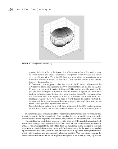
Figure 8.4 Two spheres intersecting.
portion of the circle that is the intersection of these two spheres. The receiver must
lie somewhere on this circle. The circle is a straight line when observed in a planar
or perpendicular view. There is still, however, some doubt or uncertainty as to
where the receiver is located on the circle. Thus, another beacon is still needed
to resolve the uncertainty.
• B3 flashes next, and suppose it takes 3 seconds for the B3 sound pulse to reach the
GPS receiver. This delay represents a 3300-ft sphere centered on B3. The B1, B2, and
B3 spheres are shown intersecting in Figure 8.5. The receiver must be located at the
star shown in the figure. In reality, it could be at either a high or low point since
the third sphere intersects the two other spheres at two points. The receiver position
has now been fixed with regard to x and y coordinates but not the third, or z
coordinate. Guess what? Now you need a fourth beacon to resolve whether the
receiver is at the high or low point. I am not going to go through the whole process
again; I think you have figured it out by now.
• Figure 8.5 shows a plane view of all three spheres with the GPS receiver position
shown. You can think of it as a horizontal slice taken at z = 0, as shown in Figure 8.6.
In summary, it takes a minimum of three beacons to determine the x and y coordinates and
a fourth beacon to fix the z coordinate. Now translate beacons to satellites and x, y, and z
coordinates to latitude, longitude, and altitude, and you have the basics of the real GPS system.
The satellites transmit digital microwave radio frequency (RF) signals that contain both
identity and timing components that a real GPS receiver will use to calculate its position and
altitude. The counterpart to the embedded database mentioned in my example is called an
ephemeris, or celestial almanac, that contains all the data necessary for the receiver to calculate
a particular satellite’s orbital position. All GPS satellites are in high earth orbits (as mentioned
in the history section) and are constantly changing position. This movement requires the
receiver to use a dynamic means for acquiring their position fix, which, in turn, is provided