
Page 287 - Build Your Own Quadcopter_ Power Up Your Designs with the Parallax Elev-8
P. 287
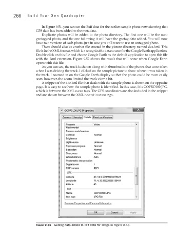
266     Bu il d  Y o ur  O w n  Q u a d c o p t e r


                                In Figure 9.51, you can see the Exif data for the earlier sample photo now showing that
                             GPS data has been added to the metadata.
                                Duplicate photos will be added to the photo directory. The first one will be the non-
                             geotagged photo, and the one following it will have the geotag data added. You will now
                             have two versions of each photo, just in case you still want to use an untagged photo.
                                There should also be another file created in the picture directory named doc.kml. This
                             file is in the XML format, which is a recognizable data source for the Google Earth application.
                             Double click on this file and choose Google Earth as the default application to open this file
                             with the .kml extension. Figure 9.52 shows the result that will occur when Google Earth
                             opens with this file.
                                As you can see, the track is shown along with thumbnails of the photos that were taken
                             when I was driving the track. I clicked on the sample picture to show where it was taken in
                             the track. I zoomed in on the Google Earth display so that the photo could be more easily
                             seen; however, the zoom limited the track view a bit.
                                A snippet of the doc.kml file that deals with the sample photo is shown on the opposite
                             page. It is easy to see how the sample photo is identified. In this case, it is GOPRO100.JPG,
                             which is between the XML name tags. The GPS coordinates are also included in the snippet
                             and are shown between the XML coordinates tags.


                             Figure 9.51  Geotag data added to Exif data for image in Figure 9.48.