
Page 283 - Build Your Own Quadcopter_ Power Up Your Designs with the Parallax Elev-8
P. 283
262 Bu il d Y o ur O w n Q u a d c o p t e r
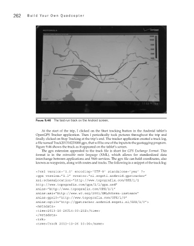
Figure 9.46 The test-run track on the Android screen.
At the start of the trip, I clicked on the Start tracking button in the Android tablet’s
OpenGPS Tracker application. Then I periodically took pictures throughout the trip and
finally clicked on Stop Tracking at the trip’s end. The tracker application created a track log,
a file named Track201310231000.gpx, that will be one of the inputs to the geotagging program.
Figure 9.46 shows the track as it appeared on the tablet’s screen.
The gpx extension appended to the track file is short for GPS Exchange Format. This
format is in the extensible meta language (XML), which allows for standardized data
interchange between applications and Web services. The gpx file can hold coordinates, also
known as waypoints, along with routes and tracks. The following is a snippet of the track log:
<?xml version=’1.0’ encoding=’UTF-8’ standalone=’yes’ ?>
<gpx version=”1.1” creator=”nl.sogeti.android.gpstracker”
xsi:schemaLocation=”http://www.topografix.com/GPX/1/1
http://www.topografix.com/gpx/1/1/gpx.xsd”
xmlns=”http://www.topografix.com/GPX/1/1”
xmlns:xsi=”http://www.w3.org/2001/XMLSchema-instance”
xmlns:gpx10=”http://www.topografix.com/GPX/1/0”
xmlns:ogt10=”http://gpstracker.android.sogeti.nl/GPX/1/0”>
<metadata>
<time>2013-10-26T14:00:25Z</time>
</metadata>
<trk>
<name>Track 2013-10-26 10:00</name>