
Page 281 - Build Your Own Quadcopter_ Power Up Your Designs with the Parallax Elev-8
P. 281
260 Bu il d Y o ur O w n Q u a d c o p t e r
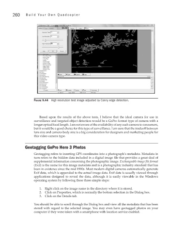
Figure 9.44 High-resolution test image adjusted by Canny edge detection.
Based upon the results of the above tests, I believe that the ideal camera for use in
surveillance and targeted-object detection would be a GoPro format type of camera with a
longer optical focal length. I am not aware of the availability of any such camera to consumers,
but it would be a good choice for this type of surveillance. I am sure that the tradeoff between
lens size and camera-body size is a big consideration for designers and marketing people for
this video camera type.
Geotagging GoPro Hero 3 Photos
Geotagging refers to inserting GPS coordinates into a photograph’s metadata. Metadata in
turn refers to the hidden data included in a digital image file that provides a great deal of
supplemental information concerning the photographic image. Exchangeable image file format
(Exif) is the name for this image metadata and is a photographic industry standard that has
been in existence since the mid 1990s. Most modern digital cameras automatically generate
Exif data, which is appended to the actual image data. Exif data is usually viewed through
applications designed to reveal the data, although it is easily viewable in the Windows
operating system by following these three simple steps:
1. Right click on the image name in the directory where it is stored.
2. Click on Properties, which is normally the bottom selection in the Dialog box.
3. Click on the Details tab.
You should be able to scroll through the Dialog box and view all the metadata that has been
stored with regard to the selected image. You may even have geotagged photos on your
computer if they were taken with a smartphone with location service enabled.