
Page 282 - Build Your Own Quadcopter_ Power Up Your Designs with the Parallax Elev-8
P. 282
Chapter 9: Airbor ne V ideo Systems 261
Caution: Photos that were taken with a smartphone and posted on the Web can inadvertently
provide GPS coordinates to anyone with an interest. You should probably avoid this if you and
your family are leaving on a road trip or vacation and take a parting photo at your home.
Geotagging is appropriate only for photographs, not video, since it is impossible to tag
every frame when they are being created 30 times per second. The Hero 3 camera has a
useful feature that takes a still photograph image every 5, 10, 30, or 60 seconds, while also
creating a video. These intermittent photos will be the ones geotagged to record your location
on the photo. Notice, that I chose the word “your” to describe the location because the GPS
coordinates will be generated by the Android tablet that is part of the ground control station
(GCS) and not by anything onboard the quadcopter. In most cases, this should not be a
problem, since you will be within 100 m (109.36 yd) of the flying quadcopter. The GCS GPS
coordinates should be sufficiently accurate for most location and identification purposes.
Geotagging photos require that a record of GPS coordinates be saved during the same
time interval that the photographs are taken. This saved record is known as a GPS track,
which is just a collection of GPS coordinates along with the time that the coordinates were
taken. It then becomes a simple task of matching the time the photograph was taken to the
matching time from the GPS track. Most digital photos have the time they were taken
recorded and stored in the Exif data. I used a program named OpenGPS Tracker to create the
GPS track that runs on a Motorola Android Zoom tablet. This tablet is part of the GCS shown
in Figure 9.19 on page 244.
Geotag Test Run
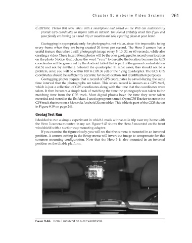
I decided to run a simple experiment in which I made a three-mile trip near my home with
the Hero 3 camera mounted in my car. Figure 9.45 shows the Hero 3 mounted on the front
windshield with a suction-cup mounting adapter.
If you examine the figure closely, you will see that the camera is mounted in an inverted
position. A camera setting in the Setup menu will invert the image to compensate for this
common mounting configuration. Note that the Hero 3 is also mounted in an inverted
position on the tiltable platform.
Figure 9.45 Hero 3 mounted on a car windshield.