
Page 60 - Carbonate Sedimentology and Sequence Stratigraphy
P. 60
CHAPTER 3: GEOMETRY OF CARBONATE ACCUMULATIONS 51
THE EMPTY BUCKET A)
sea level
At the beginning of this chapter it was pointed out that
rimmed platform have the anatomy of a bucket, composed
of a stiff rim of stacked reefs or lithified sand shoals, and
an interior of loose sediment (Ladd, 1973; Schlager, 1981). 5
The rim is not only the stiffer, more competent element of basalt
the system, it is also more productive than the platform inte-
rior. This can be shown by sediment accumulation rates (Fig.
2.22) but also by sediment anatomy: Sand shoals and reefs 10
at the platform margin commonly shed excess sediment into
the lagoon in the form of a debris apron that progrades away
from the rim (Fig. 3.19). One also observes rims that keep up
with rising sea level while the lagoon becomes submerged to 15 100 200 300 400 500
near the limits of the photic zone. This selective upbuilding B) 3
leaves the platform bucket partly empty.
mean sea level
The origin of raised rims and deep lagoons by selective 0
upbuilding of the reef rims goes back to Charles Darwin,
who included this principle in his atoll model (Darwin,
1842). An alternative explanation of empty-bucket morphol- -5 \clearpage
ogy is not quite as old. It postulates that the morphology of 5000 y
5500 y
6000 y
modern atolls is the result of differential karst weathering 6500 y
during lowstands of sea level (Ladd and Hoffmeister, 1945; 7000 y
-10 meters
MacNeil, 1954; Purdy, 1974; Winterer, 1998; Purdy and Win-
100 200 300 400 500
terer, 2001). Both hypotheses rely on theoretical concepts as
C)
well as supporting observations. The discussion in the liter- 0
ature is in full swing and, as the empty bucket is a charac-
teristic carbonate growth form, the state of the argument is
reviewed below.
The conceptual basis of the construction hypothesis is
15
the measurably higher growth potential of the rim and
the disposition of reefs to grow upward rather than mi-
grate laterally. The observational support is briefly sum-
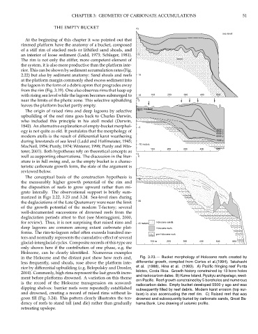
marized in Figs 2.22, 3.23 and 3.24. Sea-level rises during
the deglaciations of the Late Quaternary were near the limit 30
of the growth potential of the modern T-factory; several
well-documented successions of drowned reefs from the
deglaciation periods attest to that (see Montaggioni, 2000,
for review). Thus, it is not surprising that raised rims and 45 meters Holocene sands
deep lagoons are common among extant carbonate plat- Holocene reefs
forms. The rim-to-lagoon relief often exceeds hundred me-
pre-Holocene rock
ters and normally represents the cumulative effect of several
glacial-interglacial cycles. Composite records of this type are 100 m 200 300 400 500 600
only shown here if the contribution of one phase, e.g. the
Holocene, can be clearly identified. Numerous examples
in the Holocene and the distant past show how reefs and, Fig. 3.23.— Bucket morphology of Holocene reefs created by
less frequently, sand shoals, rose above the platform inte- differential growth, compiled from Cortes et al.(1994), Takahashi
et al. (1988), Hine et al. (1983). A) Pacific fringing reef Punta
rior by differential upbuilding (e.g. Belopolsky and Droxler,
Islotes, Costa Rica. Growth history constrained by 13 bore holes
2004). Commonly, high rims represent the last growth incre-
and radiocarbon dates. B) Kume Island, Ryukyu archipelago, west-
ment before platforms drowned. A variation on this theme
ern Pacific. Reef growth constrained by 5 boreholes and numerous
is the record of the Holocene transgression on seaward-
radiocarbon dates. Empty bucket developed 5500 y ago and was
dipping shelves: barrier reefs were repeatedly established subsequently filled by reef debris. Modern karst erosion (top sur-
and drowned, creating a record of raised rims without la- face) is also accentuating the reef rim. C) Raised reef that was
goon fill (Fig. 3.24). This pattern clearly illustrates the ten- drowned and subsequently buried by carbonate sands, Great Ba-
dency of reefs to stand tall (and die) rather than gradually hama Bank. Line drawing of seismic profile.
retreating upslope.