
Page 212 - Digital Analysis of Remotely Sensed Imagery
P. 212
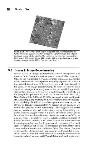
176    Cha pte r  F i v e


               FIGURE 5.14  An example of an output image that has been rectifi ed to the
               NZMG coordinate system based on a fi rst-order transformation. The edge of
               the image appears to be straight. The image’s dimension has increased to
               605 rows by 647 columns from 512 rows by 512 columns because of image
               rotation. (Copyright CNS, 1994.) See also color insert.


          5.6  Issues in Image Georeferencing
               Several issues in image georeferencing remain unexplored. For
               instance, how does the source of ground control affect accuracy?
               What is the relationship between accuracy expressed in absolute
               values in meters and that expressed relatively in pixel size? How do
               the spatial distribution of GCPs and their ease of identification affect
               the accuracy of image georeferencing? In order to answer these
               questions, a comparative study was carried out in which a portable
               Trimble Geo-Explorer GPS receiver was deployed to repeatedly log
               the geographic positions of 20 GCPs in metropolitan  Auckland,
               New Zealand (Fig. 5.15) and 25 GCPs in a rural area in northwest-
               ern China (Fig. 5.16). Working in the autonomous mode with selec-
               tive availability, the GPS receiver has a planimetric accuracy up to
               100 m, or 2dRMS (approximately 95 percent of the positions are
               within the specified value horizontally). The singular horizontal
               accuracy can be as high as 2 to 5 m via averaging differentially cor-
               rected positions logged within 3 minutes. The urban area of about
                     2
               16 km  contains ample road intersections that can serve as GCP can-
               didates. Thus, it is relatively easy to select a sufficient number of
               widely dispersed quality GCPs. Their coordinates were also read
               from a topographic map for the purpose of comparison. The rural
                                         2
               scene covering about 94 km  encompasses predominantly sand
               dunes, and to a lesser extent, cultivated fields. Few distinct features
               visible on the satellite imagery can serve as GCP candidates. Scar-
               city of these features led to the selection of unstable or inconspicu-
               ous water-related features as GCP candidates, such as sharp turning