
Page 215 - Digital Analysis of Remotely Sensed Imagery
P. 215
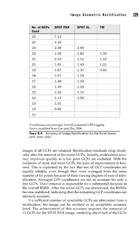
Image Geometric Rectification      179


                     No. of GCPs   SPOT PAN   SPOT XL     TM
                     Used
                     25          7.13
                     24          4.16
                     23          2.49         2.65
                     22          2.26         1.82        1.34
                     21          2.10         1.51        1.10
                     20          1.91         1.43        1.01
                     19          1.67         1.37        0.93
                     18          1.57         1.29
                     17          1.46         1.23
                     16          1.33         1.16
                     15          1.20         1.10
                     14          1.12         1.00
                     13          1.01
                     12          0.90
                     11

                   ∗ Coordinates are averaged from 60 sequential GPS logging.
                   Source: modified from Gao and Zha, 2006.
                   TABLE 5.4  Accuracy of Image Rectification for the Rural Scene
                   (unit: pixel size) ∗


               images if all GCPs are retained. Rectification residuals drop drasti-
               cally after the removal of the worst GCPs,. Initially, rectification accu-
               racy improves quickly as a few poor GCPs are excluded. With the
               exclusion of more and more GCPs, the pace of improvement is low-
               ered. This is explained by the fact that not all GCP coordinates are
               equally reliable, even though they were averaged from the same
               number of fix points because of their varying degrees of ease of iden-
               tification. Averaged GPS coordinates are not so accurate for only a
               few GCPs. Their removal is responsible for a substantial decrease in
               the overall RMSE. After the worst GCPs are abandoned, the RMSEs
               become stabilized, indicating that the remaining GCP coordinates are
               similarly accurate.
                   If a sufficient number of unreliable GCPs are eliminated from a
               rectification, the image can be rectified at an acceptable accuracy
               level. The achievement of this accuracy requires the removal of
               12 GCPs for the SPOT PAN image, rendering about half of the GCPs