
Page 227 - Digital Analysis of Remotely Sensed Imagery
P. 227
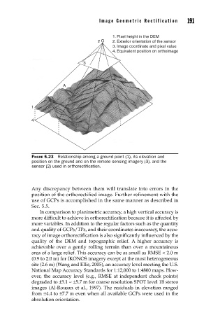
Image Geometric Rectification      191


                                               1. Pixel height in the DEM
                                         2 O   2. Exterior orientation of the sensor
                                               3. Image coordinate and pixel value
                                               4. Equivalent position on orthoimage

                                    3


                            A


               1

               4


               FIGURE 5.23  Relationship among a ground point (1), its elevation and
               position on the ground and on the remote sensing imagery (3), and the
               sensor (2) used in orthorectifi cation.


               Any discrepancy between them will translate into errors in the
               position of the orthorectified image. Further refinement with the
               use of GCPs is accomplished in the same manner as described in
               Sec. 5.5.
                   In comparison to planimetric accuracy, a high vertical accuracy is
               more difficult to achieve in orthorectification because it is affected by
               more variables. In addition to the regular factors such as the quantity
               and quality of GCPs/TPs, and their coordinates inaccuracy, the accu-
               racy of image orthorectification is also significantly influenced by the
               quality of the DEM and topographic relief.  A higher accuracy is
               achievable over a gently rolling terrain than over a mountainous
               area of a large relief. This accuracy can be as small as RMSE < 2.0 m
               (0.9 to 2.0 m) for IKONOS imagery except at the most heterogeneous
               site (2.6 m) (Wang and Ellis, 2005), an accuracy level meeting the U.S.
               National Map Accuracy Standards for 1:12,000 to 1:4800 maps. How-
               ever, the accuracy level (e.g., RMSE at independent check points)
               degraded to ±5.1 ~ ±5.7 m for coarse resolution SPOT level 1B stereo
               images (Al-Rousan et al., 1997). The residuals in elevation ranged
               from ±4.4 to ±7.7 m even when all available GCPs were used in the
               absolution orientation.