
Page 45 - Digital Analysis of Remotely Sensed Imagery
P. 45
18 Cha pte r O n e
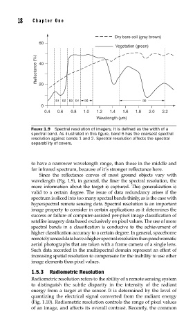
Dry bare soil (gray brown)
60
Vegetation (green)
Reflectance (%) 40
20
B1 B2 B3 B4 B5 B6
0
0.4 0.6 0.8 1.0 1.2 1.4 1.6 1.8 2.0 2.2
Wavelength (mm)
FIGURE 1.9 Spectral resolution of imagery. It is defi ned as the width of a
spectral band. As illustrated in this fi gure, band 6 has the coarsest spectral
resolution against bands 1 and 2. Spectral resolution affects the spectral
separability of covers.
to have a narrower wavelength range, than those in the middle and
far infrared spectrum, because of it’s stronger reflectance here.
Since the reflectance curves of most ground objects vary with
wavelength (Fig. 1.9), in general, the finer the spectral resolution, the
more information about the target is captured. This generalization is
valid to a certain degree. The issue of data redundancy arises if the
spectrum is sliced into too many spectral bands thinly, as is the case with
hyperspectral remote sensing data. Spectral resolution is an important
image property to consider in certain applications as it determines the
success or failure of computer-assisted per-pixel image classification of
satellite imagery data based exclusively on pixel values. The use of more
spectral bands in a classification is conducive to the achievement of
higher classification accuracy to a certain degree. In general, spaceborne
remotely sensed data have a higher spectral resolution than panchromatic
aerial photographs that are taken with a frame camera of a single lens.
Such data recorded in the multispectral domain represent an effort of
increasing spatial resolution to compensate for the inability to use other
image elements than pixel values.
1.5.3 Radiometric Resolution
Radiometric resolution refers to the ability of a remote sensing system
to distinguish the subtle disparity in the intensity of the radiant
energy from a target at the sensor. It is determined by the level of
quantizing the electrical signal converted from the radiant energy
(Fig. 1.10). Radiometric resolution controls the range of pixel values
of an image, and affects its overall contrast. Recently, the common