
Page 44 - Digital Analysis of Remotely Sensed Imagery
P. 44
Overview 17
(a) (b)
(c) (d)
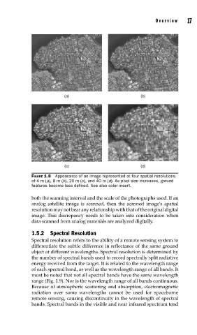
FIGURE 1.8 Appearance of an image represented at four spatial resolutions
of 4 m (a), 8 m (b), 20 m (c), and 40 m (d). As pixel size increases, ground
features become less defi ned. See also color insert.
both the scanning interval and the scale of the photographs used. If an
analog satellite image is scanned, then the scanned image’s spatial
resolution may not bear any relationship with that of the original digital
image. This discrepancy needs to be taken into consideration when
data scanned from analog materials are analyzed digitally.
1.5.2 Spectral Resolution
Spectral resolution refers to the ability of a remote sensing system to
differentiate the subtle difference in reflectance of the same ground
object at different wavelengths. Spectral resolution is determined by
the number of spectral bands used to record spectrally split radiative
energy received from the target. It is related to the wavelength range
of each spectral band, as well as the wavelength range of all bands. It
must be noted that not all spectral bands have the same wavelength
range (Fig. 1.9). Nor is the wavelength range of all bands continuous.
Because of atmospheric scattering and absorption, electromagnetic
radiation over some wavelengths cannot be used for spaceborne
remote sensing, causing discontinuity in the wavelength of spectral
bands. Spectral bands in the visible and near infrared spectrum tend