
Page 43 - Digital Analysis of Remotely Sensed Imagery
P. 43
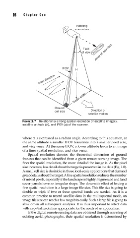
16    Cha pte r  O n e


                                             Rotating
                                            scan mirror


                                                 Field
                                                of view  Array of detectors


                                     IFOV
                                             H
                        Scan direction


                                            Swath width


                                 Ground
                                 cell size           Direction of
                                                    satellite motion
               FIGURE 1.7  Relationship among spatial resolution of satellite imagery,
               satellite altitude (H), and IFOV (a) of the scanner.


               where α is expressed as a radian angle. According to this equation, at
               the same altitude a smaller IFOV translates into a smaller pixel size,
               and vice versa. At the same IFOV, a lower altitude leads to an image
               of a finer spatial resolution, and vice versa.
                   Spatial resolution denotes the theoretical dimension of ground
               features that can be identified from a given remote sensing image. The
               finer the spatial resolution, the more detailed the image is. As the pixel
               size increases, less detail about the target is preserved in the data (Fig. 1.8).
               A small cell size is desirable in those local-scale applications that demand
               great details about the target. A fine spatial resolution reduces the number
               of mixed pixels, especially if the landscape is highly fragmented and land
               cover parcels have an irregular shape. The downside effect of having a
               fine spatial resolution is a large image file size. This file size is going to
               double or triple if two or three spectral bands are needed. As it is a
               common practice to record satellite data in the multispectral mode, an
               image file size can reach a few megabits easily. Such a large file is going to
               slow down all subsequent analyses. It is thus important to select data
               with a spatial resolution appropriate for the needs of an application.
                   If the digital remote sensing data are obtained through scanning of
               existing aerial photographs, their spatial resolution is determined by