
Page 206 - Fundamentals of Ocean Renewable Energy Generating Electricity From The Sea
P. 206
Ocean Modelling for Resource Characterization Chapter | 8 195
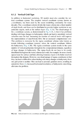
8.1.2 Vertical Grid Type
In addition to horizontal resolution, 3D models must also consider the ver-
tical coordinate system. The simplest vertical coordinate system, known as
z-coordinates, has been used by the ocean modelling community for many
decades. The z-coordinate scheme divides the water column into a fixed number
of depth levels, and these can be distributed to provide higher resolution in any
particular region, such as the surface layer (Fig. 8.2A). The disadvantage of
the z-coordinate system, as demonstrated in Fig. 8.2A, is that it has problems
dealing with large changes in bathymetry, which can lead to unrealistic vertical
velocities near the bed. Increasing the number of vertical levels will improve
the representation of near-bottom flow, but at increased computational cost.
This problem is overcome by the sigma coordinate scheme (also known as
terrain following coordinate system), where the vertical coordinate follows
the bathymetry (Fig. 8.2B). The sigma coordinate system results in the same
number of vertical grid points throughout the computational domain, regardless
of large changes in bathymetry. The sigma levels do not have to be evenly
distributed throughout the water column and could, for example, be more closely
spaced near the surface and bed, allowing boundary layers to be better resolved
throughout the domain. However, one disadvantage of sigma coordinates is that
they can lead to difficulties when dealing with sharp changes in bathymetry from
one grid point to another. This can lead to pressure gradient errors, resulting in
unrealistic flows [1]. Increased horizontal resolution, or bathymetric smoothing,
alleviates the problem.
FIG. 8.2 Vertical mesh for (A) z-coordinate and (B) sigma coordinate systems.