
Page 243 - Geochemical Anomaly and Mineral Prospectivity Mapping in GIS
P. 243
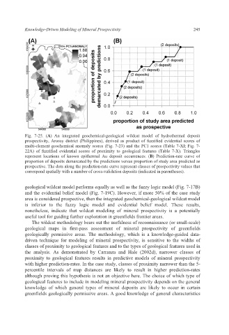
Knowledge-Driven Modeling of Mineral Prospectivity                   245


           Fig. 7-25. (A)  An integrated geochemical-geological  wildcat  model of hydrothermal deposit
           prospectivity, Aroroy district (Philippines), derived as product  of fuzzified evidential scores of
           multi-element geochemical anomaly scores (Fig. 7-23) and the PC1 scores (Table 7-XI; Fig. 7-
           22A) of fuzzified evidential scores of proximity to geological features (Table 7-X).  Triangles
           represent locations of known epithermal Au deposit occurrences. (B) Prediction-rate  curve of
           proportion of deposits demarcated by the predictions versus proportion of study area predicted as
           prospective. The dots along the prediction-rate curve represent classes of prospectivity values that
           correspond spatially with a number of cross-validation deposits (indicated in parentheses).


           geological wildcat model performs equally as well as the fuzzy logic model (Fig. 7-17B)
           and the evidential belief model (Fig. 7-19C). However, if more 50% of the case study
           area is considered prospective, then the integrated geochemical-geological wildcat model
           is inferior to the  fuzzy logic model and evidential belief model. These results,
           nonetheless, indicate that wildcat  modeling of mineral  prospectivity is a potentially
           useful tool for guiding further exploration in greenfields frontier areas.
              The wildcat methodology bears out the usefulness of reconnaissance (or small-scale)
           geological maps in first-pass assessment of mineral prospectivity  of greenfields
           geologically permissive areas. The methodology, which  is a knowledge-guided data-
           driven technique for modeling of mineral prospectivity, is sensitive to the  widths  of
           classes of proximity to geological features and to the types of geological features used in
           the analysis. As demonstrated by Carranza and  Hale (2002d), narrower classes  of
           proximity to geological features results in  predictive models of mineral prospectivity
           with higher prediction-rates. In the case study, classes of proximity narrower than the 5-
           percentile intervals  of map distances are likely to result in higher  prediction-rates
           although proving this hypothesis is not an objective here. The choice of which type of
           geological features to include in modeling mineral prospectivity depends on the general
           knowledge of  which general types of mineral deposits are likely to occur in certain
           greenfields geologically permissive areas. A good knowledge of general characteristics