
Page 29 - Geochemical Anomaly and Mineral Prospectivity Mapping in GIS
P. 29
Spatial Data Models, Management and Operations 25
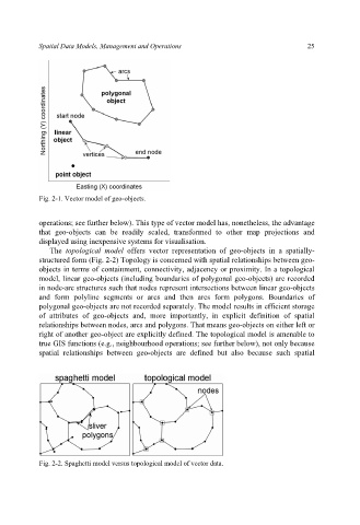
Fig. 2-1. Vector model of geo-objects.
operations; see further below). This type of vector model has, nonetheless, the advantage
that geo-objects can be readily scaled, transformed to other map projections and
displayed using inexpensive systems for visualisation.
The topological model offers vector representation of geo-objects in a spatially-
structured form (Fig. 2-2) Topology is concerned with spatial relationships between geo-
objects in terms of containment, connectivity, adjacency or proximity. In a topological
model, linear geo-objects (including boundaries of polygonal geo-objects) are recorded
in node-arc structures such that nodes represent intersections between linear geo-objects
and form polyline segments or arcs and then arcs form polygons. Boundaries of
polygonal geo-objects are not recorded separately. The model results in efficient storage
of attributes of geo-objects and, more importantly, in explicit definition of spatial
relationships between nodes, arcs and polygons. That means geo-objects on either left or
right of another geo-object are explicitly defined. The topological model is amenable to
true GIS functions (e.g., neighbourhood operations; see further below), not only because
spatial relationships between geo-objects are defined but also because such spatial
Fig. 2-2. Spaghetti model versus topological model of vector data.