
Page 34 - Geochemical Anomaly and Mineral Prospectivity Mapping in GIS
P. 34
30 Chapter 2
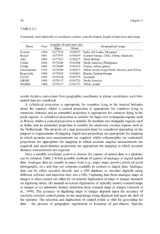
TABLE 2-I
Commonly used spheroids of coordinate systems: year developed, length of semi-axes and usage.
Lengths of semi-axes (m)
Name Year Geographical usage
Major Minor
Everest 1830 6377276 6356075 India, Sri Lanka, Myanmar
Bessel 1841 6377397 6356079 Central Europe, Chile, China, Indonesia
Airy 1849 6377563 6356257 Great Britain
Clarke 1866 6378206 6356584 North America, Philippines
Clarke 1880 6378249 6356515 France, Africa (parts)
International 1924 6378388 6356912 Whole word except North America and Africa
Krasovsky 1940 6378245 6356863 Russia, Eastern Europe
IAU65 1965 6378160 6356775 Australia
GRS80 1980 6378137 6356752 North America
WGS84 1984 6378137 6356752 Whole world
avoids iterative conversion from geographic coordinates to planar coordinates each time
spatial data are visualised.
A cylindrical projection is appropriate for countries lying in the tropical latitudes
about the equator, whilst a conical projection is appropriate for countries lying in
temperate latitudes and an azimuthal projection is appropriate for countries lying in the
polar regions. A cylindrical projection is suitable for large-size rectangular regions such
as Russia, whilst a conical projection is suitable for medium-size triangular regions such
as India, and an azimuthal projection is suitable for small-size circular regions such as
the Netherlands. The property of a map projection must be considered depending on the
purpose or requirements of mapping. Equal-area projections are appropriate for mapping
in which accurate area measurements are required, whilst orthomorphic (or conformal)
projections are appropriate for mapping in which accurate angular measurements are
required, and equal-distance projections are appropriate for mapping in which accurate
distance measurements are required.
Once a suitable coordinate system is chosen, the capture of spatial data to a database
can be initiated. Table 2-II lists possible methods of capture of analogue or digital spatial
data. Analogue data are usually in paper form (e.g., paper maps, positive prints of aerial
photographs, etc.) and thus not computer-readable in contrast to digital data. Analogue
data can be either encoded directly into a GIS database or encoded digitally using
different software and imported later into a GIS. Capturing data from analogue maps or
images is often carried out either by (a) manual digitisation of maps or images mounted
on digitising tables, (b) manual on-screen digitisation of optically (raster) scanned maps
or images or (c) automatic feature extraction from scanned maps or images (Ansoult et
al., 1990). The accuracy of digitising maps or images depends upon the accuracy of
carefully-selected control points on the map/image being digitised and upon the skill of
the operator. The selection and digitisation of control points is vital for geocoding the
data – the process of geographic registration of locations of geo-objects. Specific