
Page 35 - Geochemical Anomaly and Mineral Prospectivity Mapping in GIS
P. 35
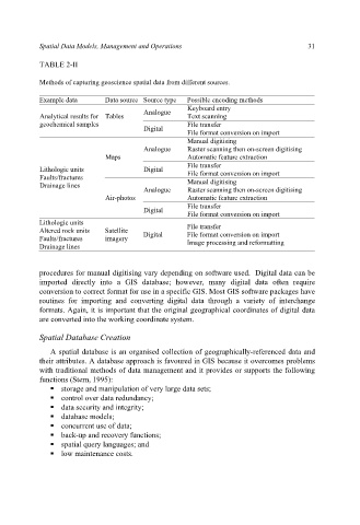
Spatial Data Models, Management and Operations 31
TABLE 2-II
Methods of capturing geoscience spatial data from different sources.
Example data Data source Source type Possible encoding methods
Keyboard entry
Analogue
Analytical results for Tables Text scanning
geochemical samples File transfer
Digital
File format conversion on import
Manual digitising
Analogue Raster scanning then on-screen digitising
Maps Automatic feature extraction
File transfer
Lithologic units Digital File format conversion on import
Faults/fractures
Drainage lines Manual digitising
Analogue Raster scanning then on-screen digitising
Air-photos Automatic feature extraction
File transfer
Digital
File format conversion on import
Lithologic units File transfer
Altered rock units Satellite Digital File format conversion on import
Faults/fractures imagery Image processing and reformatting
Drainage lines
procedures for manual digitising vary depending on software used. Digital data can be
imported directly into a GIS database; however, many digital data often require
conversion to correct format for use in a specific GIS. Most GIS software packages have
routines for importing and converting digital data through a variety of interchange
formats. Again, it is important that the original geographical coordinates of digital data
are converted into the working coordinate system.
Spatial Database Creation
A spatial database is an organised collection of geographically-referenced data and
their attributes. A database approach is favoured in GIS because it overcomes problems
with traditional methods of data management and it provides or supports the following
functions (Stern, 1995):
storage and manipulation of very large data sets;
control over data redundancy;
data security and integrity;
database models;
concurrent use of data;
back-up and recovery functions;
spatial query languages; and
low maintenance costs.