
Page 39 - Geochemical Anomaly and Mineral Prospectivity Mapping in GIS
P. 39
Spatial Data Models, Management and Operations 35
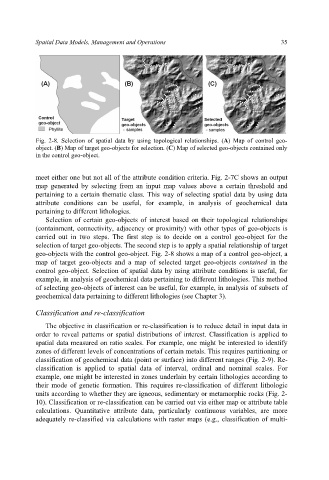
Fig. 2-8. Selection of spatial data by using topological relationships. (A) Map of control geo-
object. (B) Map of target geo-objects for selection. (C) Map of selected geo-objects contained only
in the control geo-object.
meet either one but not all of the attribute condition criteria. Fig. 2-7C shows an output
map generated by selecting from an input map values above a certain threshold and
pertaining to a certain thematic class. This way of selecting spatial data by using data
attribute conditions can be useful, for example, in analysis of geochemical data
pertaining to different lithologies.
Selection of certain geo-objects of interest based on their topological relationships
(containment, connectivity, adjacency or proximity) with other types of geo-objects is
carried out in two steps. The first step is to decide on a control geo-object for the
selection of target geo-objects. The second step is to apply a spatial relationship of target
geo-objects with the control geo-object. Fig. 2-8 shows a map of a control geo-object, a
map of target geo-objects and a map of selected target geo-objects contained in the
control geo-object. Selection of spatial data by using attribute conditions is useful, for
example, in analysis of geochemical data pertaining to different lithologies. This method
of selecting geo-objects of interest can be useful, for example, in analysis of subsets of
geochemical data pertaining to different lithologies (see Chapter 3).
Classification and re-classification
The objective in classification or re-classification is to reduce detail in input data in
order to reveal patterns or spatial distributions of interest. Classification is applied to
spatial data measured on ratio scales. For example, one might be interested to identify
zones of different levels of concentrations of certain metals. This requires partitioning or
classification of geochemical data (point or surface) into different ranges (Fig. 2-9). Re-
classification is applied to spatial data of interval, ordinal and nominal scales. For
example, one might be interested in zones underlain by certain lithologies according to
their mode of genetic formation. This requires re-classification of different lithologic
units according to whether they are igneous, sedimentary or metamorphic rocks (Fig. 2-
10). Classification or re-classification can be carried out via either map or attribute table
calculations. Quantitative attribute data, particularly continuous variables, are more
adequately re-classified via calculations with raster maps (e.g., classification of multi-