
Page 30 - Geochemical Anomaly and Mineral Prospectivity Mapping in GIS
P. 30
26 Chapter 2
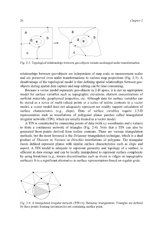
Fig. 2-3. Topological relationships between geo-objects remain unchanged under transformation.
relationships between geo-objects are independent of map scale or measurement scales
and are preserved even under transformations to various map projections (Fig. 2-3). A
disadvantage of the topological model is that defining spatial relationships between geo-
objects during spatial data capture and map editing can be time-consuming.
Because a vector model represents geo-objects in 2-D space, it is not an appropriate
model for surface variables such as topographic elevations, element concentrations of
surficial materials, geophysical properties, etc. Although data for surface variables can
be stored as a series of multi-valued points or a series of isoline contours in a vector
model, a vector model does not adequately represent nor readily support calculation of
surface characteristics (e.g., slope). Data of surface variables require 2.5-D
representation such as tessellations of polygonal planar patches called triangulated
irregular networks (TIN), which are usually treated as a vector model.
A TIN is constructed by connecting points of data (with x,y coordinates and z-values)
to form a continuous network of triangles (Fig. 2-4). Note that a TIN can also be
generated from points derived from isoline contours. There are various triangulation
methods, but the most favoured is the Delaunay triangulation technique, which is a dual
product of Thiessen or Voronoi or Dirichlet tessellations of polygons. The triangular
facets defined represent planes with similar surface characteristics such as slope and
aspect. A TIN model is adequate to represent geometry and topology of a surface, is
efficient in data storage and can be locally manipulated to represent surface complexity
by using breaklines (e.g., terrain discontinuities such as rivers or ridges on topographic
surfaces). It is a significant alternative to surface representations based on regular grids.
Fig. 2-4. A triangulated irregular network (TIN) by Delaunay triangulation. Triangles are defined
by three points forming circumcircles not containing another point.