
Page 215 - Geochemical Remote Sensing of The Sub-Surface
P. 215
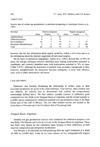
192                                     V. 7". Jones, M.D. Matthews and D.M. Richers
           TABLE 5-XVI

           Success  rates of surface gas geochemistry in petroleum prospecting in Azerbaijan (Zorkin  et al.,
           1982)

           Province                     Positive prognosis       Negative prognosis
                                  Areas   Correct     %     Areas   Correct     %
           Apsheronskaya               8        7       87       -        -      -
           N izh n i ek uri n skaya    4        3       75       -        -      -
           Kirovobadskaya             10        7      70        8        7     87
           Kobystano-Shemahinskaya     4        2      50        6        6    100
           Total                      26       19      70       14       13     90


           however,  the  risk that  information  about  spatial  variability  within  a  cell  is  lost  and  so  is
           the information about the absolute  magnitude  of individual  samples.
              On  the  basis  of anomalous  magnitudes,  Zorkin  et  al.  (1982)  showed  that,  in  90%  of
           cases,  the  soil-gas  technique  correctly  identified  areas  lacking  hydrocarbon  potential  in
           Azerbaijan,  and  correctly  identified  areas  with  hydrocarbon  potential  in  70%  of  cases
           (Table  5-XVI).  Although  the  distinction  of ambient  from secondary  background  is often
           relatively  straightforward,  the  distinction  becomes  ambiguous  in  areas  with  effective
           seals, such as stable  intracratonic  salt basins.


           CASE HISTORIES

              Numerous  case  histories  illustrating  the  relationship  of  surface  seeps  to  their
           associated  production  are  given  in  the  cited  references.  Four  surveys,  three  onshore  and
           one  offshore,  are  selected  here  to  demonstrate  and  confirm  the  compositional
           relationships  defined  above.  The  first  onshore  example  consists  of  calibration  grids
           conducted  over two  fields  in the Neuquen  Basin of Argentina,  and the  second  example  is
           a sniffer survey conducted  for calibration  purposes  over gas-productive  areas  in the  High
           Island  area  of  the  Gulf  of  Mexico.  The  two  other  onshore  surveys  are  located  in  the
           Great Basin of Nevada  and in the Overthrust Belt of Wyoming-Utah.


           Neuquen  Basin,  Argentina

              Detailed  soil  gas  geochemical  surveys  were  conducted  for  calibration  purposes  over
           two  fields, Filo Morado  and Loma de La Lata,  in the Neuquen  Basin  in Argentina.  These
           two  fields  were  chosen  for  this  calibration  study  because  of  their  differences  in  both
           reservoir composition and entrapment mechanisms.
              Filo  Morado  is an anticlinal  oil  field producing  from the  Agrio  Formation  at  a  depth
           of  3000  m  (10,000  feet).  Loma  de  La  Lata  consists  of  two  stratigraphically-trapped