
Page 224 - Geochemical Remote Sensing of The Sub-Surface
P. 224
200 V. 7". Jones, M.D. Matthews and D. Richers
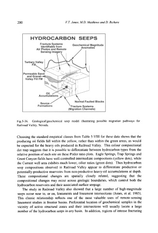
Fig.5-36. Geological/geochemical seep model illustrating possible migration pathways for
Railroad Valley, Nevada.
Choosing the standard empirical classes from Table 5-VIII for these data shows that the
producing oil fields fall within the yellow, rather than within the green areas, as would
be expected for the heavy oils produced in Railroad Valley. This colour compositional
dot map suggests that it is possible to differentiate between hydrocarbon types from the
relative position of each site on these Pixler ratio plots. Eagle Springs, Trap Springs and
Grant Canyon fields have well-controlled intermediate compositions (yellow dots), while
the Currant well area exhibits much lower, oilier ratios (green dots). Thus hydrocarbon
seep compositions observed in Railroad Valley appear to differentiate productive or
potentially-productive reservoirs from non-productive heavy-oil accumulations at depth.
These compositional changes are spatially closely related, suggesting that the
compositional changes may occur across geologic boundaries, which control both the
hydrocarbon reservoirs and their associated surface seepage.
The study in Railroad Valley also showed that a large number of high-magnitude
seeps occur near to, or on, lineaments and lineament intersections (Jones, et al. 1985).
This classic relationship reflects one of the most valuable uses of remote-sensing
lineament studies in frontier basins. Preferential location of geochemical samples in the
vicinity of active structural zones and their intersections will usually locate a large
number of the hydrocarbon seeps in any basin. In addition, regions of intense fracturing