
Page 221 - Geochemical Remote Sensing of The Sub-Surface
P. 221
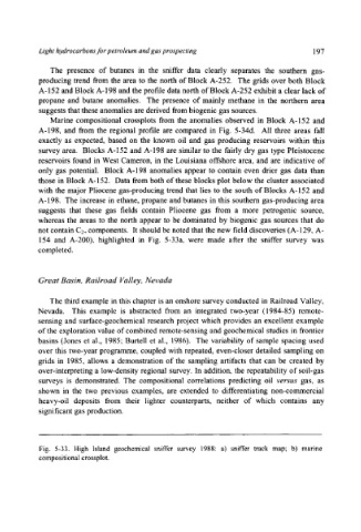
Light hydrocarbons for petroleum and gas prospecting                  197


              The  presence  of  butanes  in  the  sniffer  data  clearly  separates  the  southern  gas-
           producing trend  from the  area  to the  north  of Block  A-252.  The  grids  over both Block
           A-152  and Block A-198 and the profile data north of Block A-252  exhibit a clear lack of
           propane  and  butane  anomalies.  The  presence  of mainly  methane  in  the  northern  area
           suggests that these anomalies are derived from biogenic gas sources.
              Marine  compositional  crossplots  from  the  anomalies  observed  in  Block  A-152  and
           A-198,  and  from  the  regional  profile  are  compared  in  Fig.  5-34d.  All  three  areas  fall
           exactly  as  expected,  based  on  the  known  oil  and  gas  producing  reservoirs  within  this
           survey area.  Blocks A-152  and A-198  are  similar to the  fairly dry gas type  Pleistocene
           reservoirs found  in West Cameron,  in the  Louisiana offshore  area,  and  are  indicative  of
           only gas potential.  Block  A-198  anomalies  appear  to  contain  even  drier  gas  data  than
           those  in Block A-152.  Data from both of these  blocks plot below the  cluster associated
           with the  major Pliocene  gas-producing trend  that  lies to  the  south of Blocks  A-152  and
           A-198.  The increase  in ethane,  propane  and butanes  in this  southern gas-producing area
           suggests  that  these  gas  fields  contain  Pliocene  gas  from  a  more  petrogenic  source,
           whereas  the  areas  to  the  north  appear  to  be  dominated  by biogenic  gas  sources  that  do
           not contain C2+ components.  It should be noted that the new field discoveries (A-129,  A-
           154  and  A-200),  highlighted  in  Fig.  5-33a,  were  made  after  the  sniffer  survey  was
           completed.


           Great Basin,  Railroad  Valley,  Nevada

              The third example  in this chapter  is an onshore survey conducted  in Railroad  Valley,
           Nevada.  This  example  is  abstracted  from  an  integrated  two-year  (1984-85)  remote-
           sensing  and  surface-geochemical  research  project  which  provides  an  excellent  example
           of the exploration value of combined remote-sensing and geochemical  studies  in frontier
           basins  (Jones  et  al.,  1985;  Burtell  et  al.,  1986).  The  variability  of sample  spacing  used
           over this two-year programme,  coupled  with repeated,  even-closer detailed  sampling  on
           grids  in  1985,  allows  a  demonstration  of the  sampling  artifacts  that  can  be  created  by
           over-interpreting  a low-density regional  survey.  In addition,  the  repeatability  of soil-gas
           surveys  is  demonstrated.  The  compositional  correlations  predicting  oil  versus  gas,  as
           shown  in  the  two  previous  examples,  are  extended  to  differentiating  non-commercial
           heavy-oil  deposits  from  their  lighter  counterparts,  neither  of  which  contains  any
           significant gas production.


           Fig.  5-33. High Island geochemical sniffer survey  1988:  a)  sniffer track map; b)  marine
           compositional crossplot.