
Page 264 - Geochemical Remote Sensing of The Sub-Surface
P. 264
Aerospace detection of hydrocarbon-induced alteration 23 7
characteristics can be used in remote sensing data-processing to separate bleached red
beds from their unbleached equivalents.
In the Cement oil-field area of Oklahoma, Donovan (1974) reported that the colour
of the Permian Rush Springs formation grades from reddish-brown for unaltered
sandstone adjacent to the field, to pink, yellow and white along the flanks of the Cement
anticline, then to white along the flanks of the anticlinal axis. The white colour reflects
maximum bleaching and maximum iron loss. Similar changes are observed at the nearby
Velma, Eola, Healdton, and Chickaska fields (Ferguson, 1979a, 1979b; Donovan et al.,
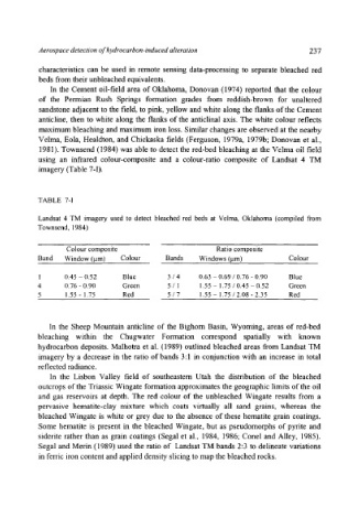
1981). Townsend (1984) was able to detect the red-bed bleaching at the Velma oil field
using an infrared colour-composite and a colour-ratio composite of Landsat 4 TM
imagery (Table 7-I).
TABLE 7-I
Landsat 4 TM imagery used to detect bleached red beds at Veima, Oklahoma (compiled from
Townsend, 1984)
Colour composite Ratio composite
Band Window (~tm) Colour Bands Windows (I.tm) Colour
1 0.45 - 0.52 Blue 3 / 4 0.63 - 0.69 / 0.76 - 0.90 Blue
4 0.76 - 0.90 Green 5 / ! 1.55 - 1.75 / 0.45 - 0.52 Green
5 1.55 - 1.75 Red 5 / 7 !.55 - 1.75 / 2.08 - 2.35 Red
In the Sheep Mountain anticline of the Bighorn Basin, Wyoming, areas of red-bed
bleaching within the Chugwater Formation correspond spatially with known
hydrocarbon deposits. Malhotra et al. (1989) outlined bleached areas from Landsat TM
imagery by a decrease in the ratio of bands 3:1 in conjunction with an increase in total
reflected radiance.
In the Lisbon Valley field of southeastern Utah the distribution of the bleached
outcrops of the Triassic Wingate formation approximates the geographic limits of the oil
and gas reservoirs at depth. The red colour of the unbleached Wingate results from a
pervasive hematite-clay mixture which coats virtually all sand grains, whereas the
bleached Wingate is white or grey due to the absence of these hematite grain coatings.
Some hematite is present in the bleached Wingate, but as pseudomorphs of pyrite and
siderite rather than as grain coatings (Segal et al., 1984, 1986; Conel and Alley, 1985).
Segal and Merin (1989) used the ratio of Landsat TM bands 2:3 to delineate variations
in ferric iron content and applied density slicing to map the bleached rocks.