
Page 106 - Geothermal Energy Renewable Energy and The Environment
P. 106
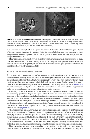
92                           Geothermal Energy: Renewable Energy and the Environment


                      193 km                          53 km

            FIGUre 6.1  (See color insert following page 17.0..) Maps of Iceland and Hawaii showing the sites of geo-
            thermal power generation facilities (stars) and the approximate locations of active or recently active volcanic
            centers (red circles). The heavy black line on the Iceland map outlines the region of active rifting. (From
            Arnórsson, S., Geothermics, 24:561–602, 1995. With permission.)

            of the volcano, allowing fluids to escape to the surface. Yellowstone National Park is probably one
            of the best known examples of a caldera. Hot water pools, bubbling mud pots, steaming streams,
            and geysers are obvious expressions of an active system in which water is heated at depth and then
            escapes to the surface.
              Many geothermal systems, however, do not have such dramatic surface manifestations. In many
            instances this absence of surface activity is due to the stage of geological evolution the site has
            reached. However, certain geological features can provide evidence of past geothermal activity that
            would potentially justify additional study.


            faulTinG and associaTed rocK alTeraTion
            For both magmatic systems as well as low temperature systems not supported by magma, heat is
            brought to the surface by water that has circulated to depths sufficient to be heated significantly in
            excess of ambient temperatures. Such systems generally involve fluid flow pathways that are made
            up of fractured or porous rocks and relatively high hydrostatic heads. Surface water circulates to
            depth from an elevated recharge region, often gaining access to deep levels via faults (Figure 6.2).
            As the fluid migrates to depth and is heated, fluid circulation becomes channeled along permeable
            paths that eventually reach the surface where the hot water emerges.
              Knowledge of the fault geometry and fault history of a region can provide crucial information
            for identifying geothermal targets. In regions where tectonic processes have resulted in extensive
            extension of the crust, hot springs indicative of geothermal resources can often be found associated
            with faults that have formed between the down-dropped valleys and bounding highland regions
            that are typical of such regimes. The Basin and Range province of the western United States is an
            excellent example of such an environment, as is the Taupo Volcanic zone on the North Island of
            New Zealand. Both of these regions are extensively faulted and have associated with them recent
            volcanic activity (Figure 6.2).
              The absence of hot springs, however, is not proof that geothermal resources are absent. Circulating
            fluids in active tectonic environments move along pathways that are susceptible to loss of perme-
            ability by tectonic and chemical processes. In regions characterized by active tectonism recurring
            seismic events will inevitably lead to modification of the fault network by changing the properties
            of a fault through repeated slippage, or by short-circuiting existing fault and fluid-flow systems by
            initiation of new faults that cross-cut old ones. When this happens, upwardly ascending water may
            be blocked from reaching the surface by impermeable barriers that develop during seismic events.
              Fluid circulation paths will also be modified as hot waters move through permeable zones. As
            water is heated, it will tend to dissolve minerals along the flow path, as discussed in Chapter 5,