
Page 248 - Global Tectonics
P. 248
234 CHAPTER 8
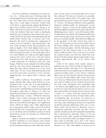
In northern California, earthquakes reveal the pres- plate velocity, those on the Pacific plate move toward
ence of a ∼120-km-wide zone of faulting within the the northwest. The observed velocities vary smoothly
Coast Ranges between the Pacific plate on the west and across the San Andreas Fault. Two profiles (Fig. 8.19b)
the Great Valley–Sierra Nevada microplate on the east (gray shaded areas) show similar total velocity changes
−1
(Fig. 8.18a). In this region, horizontal velocities (Fig. of ∼42 mm a but distinctly different velocity gradients.
8.18b) show an approximately uniform distribution of Along the northern profile, the fault-parallel velocity
−1
right lateral motion toward N29°W (Savage et al., drops by ∼30 mm a across the San Andreas Fault and
2004a). This direction is close to the local strike (N34°W) decreases slightly through the San Joaquin Valley before
−1
of the San Andreas Fault and results in dominantly distributing some 12 mm a across the Eastern Califor-
strike-slip motion along the major faults in the area. A nia Shear Zone. By contrast, the southern profi le shows
velocity profile along a great circle passing through the a total velocity drop across a distance that is about 50%
Pacific–North America pole of rotation (Fig. 8.18c) that in the northern profi le. This reflects the difference
illustrates this result by showing the components of in the geometry of the fault system from north to
motion that occur parallel to and perpendicular to the south. The flat portion of the northern profi le mirrors
trace of the San Andreas Fault. Slip rates parallel to the the relative stability of the ∼200-km-wide Great Valley–
fault are highest. Other faults display lower rates. In Sierra Nevada microplate, with the deforming central
addition, the westward movement of the Great Valley– segment of the San Andreas Fault to the west and
Sierra Nevada block relative to the Pacifi c plate (Dixon Eastern California Shear Zone to the east. By contrast,
et al., 2000; Williams et al., 2006) and the slight obliquity the southern profile shows that the 40-km-wide zone
between this motion and the trace of the San Andreas between the San Andreas and San Jacinto faults accom-
Fault (Prescott et al., 2001; Savage et al., 2004a) produces modates approximately 80% of the relative plate
a small component of contraction across the Coast motion.
Ranges. This latter result is supported by both geologic North of the Garlock Fault, relative motion is
data (Fig. 8.7b, inset) and by earthquake focal mecha- deflected east of the Sierra Nevada by deformation in
nisms that show thrust solutions west of the Great the southern Walker Lane (Figs 7.9, 8.1). This eastward
Valley (Fig. 7.10). By contrast, little deformation occurs defl ection reflects an extensional step-over between the
across the Great Valley and within the Sierra Nevada, northwest-trending faults of the Eastern California
suggesting that these regions form a coherent, rigid Shear Zone and those located along the eastern margin
block. of the Sierra Nevada (Oldow, 2003). North of the step-
In southern California, the distribution of earth- over, the zone of deformation broadens into the central
quakes indicates that relative plate motion is accom- and northern Walker Lane and central Nevada seismic
modated across a zone that is several hundreds of belt (Fig. 8.20a). Earthquake focal mechanisms (Fig.
kilometers wide (Fig. 7.8). South of latitude 34°N, 7.10) indicate that displacements in these latter belts
some motion is distributed between the San Jacinto and involve both strike-slip and normal fault motion on vari-
San Andreas faults (Fig. 8.1). Becker et al. (2005) esti- ably oriented faults. Horizontal velocities increase from
−1
−1
−1
mated that the former accommodates some 15 mm a 2–3 mm a to ∼14 mm a from the central Great Basin
−1
of slip and the latter ∼23 mm a . Within the Transverse (Section 7.3) toward the Sierra Nevada (Oldow, 2003).
Ranges, where crustal shortening and surface uplift Accompanying this rate increase, the directions of
accommodate a component of the motion (Fig. 8.8), motion rotate clockwise from west-northwest to north-
slip on the San Andreas Fault appears to be signifi cantly west (Fig. 8.20b), indicating an increase in a component
slower (Meade & Hager, 2005). Other displacements of dextral strike-slip deformation from east to west.
occur along major sinistral faults, such as the Garlock, Oldow (2003) showed that two distinctive zones of
Raymond Hill, and Cucamonga faults (Fig. 8.8a), and transtension characterize this belt: one that is domi-
by the clockwise and anticlockwise rotation of crustal nated by extension on the west (domain III) and another
blocks about vertical axes (Savage et al., 2004b; Bos & that is dominated by strike-slip motion on the east
Spakman, 2005). (domain II in Fig. 8.20b). Together with deformation in
Figure 8.19a shows an example of a velocity fi eld for the central and eastern Basin and Range (Section 7.3),
southern California in a local reference frame (Meade these belts accommodate up to 25% of the relative
& Hager, 2005). Stations on the North American plate motion between the Pacific and North American plates
move toward the southeast at about half of the relative (Bennett et al., 1999). This transfer of motion east of