
Page 257 - Hydrogeology Principles and Practice
P. 257
HYDC06 12/5/05 5:34 PM Page 240
240 Chapter Six
BO X
Nitrate contamination of the Jersey bedrock aquifer
6.6
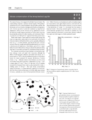
The island of Jersey is the largest of the British Channel Islands. The et al. 1998). Otherwise, local variations in well and borehole depths
island setting comprises a plateau, formed largely of Precambrian and local land-use and agricultural practices, combined with the
crystalline rocks, with a steep topographic rise along the coastline. The physical heterogeneity of the aquifer, produced no obvious pattern
temperate maritime climate encourages early flowers and vegetables, in the distribution of nitrate. It is concluded that the source of
with intensive agricultural production sustained by large fertilizer dissolved nitrate in the Jersey bedrock aquifer is primarily a result
applications. During winter and early spring, applications of nitro- of the intensive agricultural and horticultural practices and high
gen fertilizer to early-cropping potatoes and horticultural crops may livestock densities on the island. In some areas, domestic pollution
exacerbate the problem of nutrient leaching, with estimates of leach- from septic tank discharges is a further potential hazard.
−1
ing losses of up to 100 kg N ha expected from Jersey potato crops.
Mains water supply is principally from surface water storage, but
there are large areas, particularly in the rural north of the island,
that are reliant on well and borehole supplies, typically yielding less
−1
than 0.5 L s , to meet domestic, agricultural and light industrial
demands. The main aquifer and isolated perched aquifers occur within
a shallow zone of weathering in the bedrock, up to 25 m in depth
below the water table surface, with groundwater flow almost entirely
dependent on secondary permeability, imparted by dilated fractures.
The chemical composition of groundwater is controlled by mari-
time recharge inputs and water–rock interaction, although the
effects of anthropogenic pollution, particularly from nitrate, are in
places severe. A 1995 survey of groundwater quality at 46 locations
across the island produced the regional distribution of nitrate
shown in Fig. 1. Elevated nitrate concentrations occurred across
−1
much of the island and ranged from undetected to 215 mg L , with
a mean value of 71 mg L −1 (Fig. 2). Of the total, 67% of samples
exceeded the European Union water quality standard for nitrate in
−1
drinking water of 50 mg L . The high nitrate concentrations
appear to decrease in a coastal direction, especially in those sam-
Fig. 2 Histogram of groundwater nitrate concentrations in
ples from the central southern area and in the valley areas around
the Jersey bedrock aquifer sampled in June 1995. After Green
St Saviour, probably as a result of localized denitrification (Green
et al. (1998).
Fig. 1 Regional distribution of
groundwater nitrate concentrations in
the Jersey bedrock aquifer sampled in
June 1995. The absence of a regional
pattern is due to differences in land use
and inorganic nitrogen fertilizer and
cattle manure inputs, variable recharge
rates across the island and the physical
heterogeneity of the weathered bedrock
aquifer that leads to unpredictable
borehole yields and groundwater
flowpaths. After Green et al. (1998).