
Page 264 - Hydrogeology Principles and Practice
P. 264
HYDC06 12/5/05 5:34 PM Page 247
Groundwater quality and contaminant hydrogeology 247
BO X
Continued
6.7
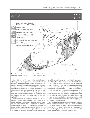
Fig. 4 Evolution of saline intrusion in the Lower Llobregat deep delta aquifer as indicated by the progressive encroachment of water
−1
with a chloride content above 1000 mg L . After Iribar et al. (1997).
Since 1950, the Lower Valley and the delta aquifers have been permeability zone, coinciding with the pre-glaciation palaeovalley
intensively exploited for groundwater as an important supply of the Llobregat river. At the eastern boundary of the delta, the deep
source and an emergency reserve. However, over-exploitation has aquifer is covered by a sandy formation, and seawater penetration
caused a depression of the potentiometric surface in the central is only hindered by thin muddy deposits present on the sea bed. At
area (Fig. 2) and the salinization of 30% of the confined aquifer the south-west delta boundary, a former saline water body existed
below the delta. Wells near the greatest part of the potentiometric as the remnant of incomplete flushing of marine water by freshwa-
depression draw water both supplied as recharge from the Lower ter. Since 1965, abstractions along this south-west boundary have
Valley and groundwater from the seaward margin. Monitoring of reversed the process of slow flushing and saline water has now pen-
water levels and chloride concentrations is well documented at the etrated towards the main wells in the area, causing the unconfined
position where the Lower Valley aquifer meets the deep delta aquifer in this coastal zone to become brackish. Two of the plumes
aquifer (Fig. 3). merge at the delta centre, leaving a freshwater pocket surrounded
The displacement of the 1000 mg L −1 isochlor (often chosen to by saline water, the surface area of which is decreasing owing to
delineate a saltwater front) is indicated for the Lower Valley and groundwater abstractions within it.
delta by comparing the time evolution of chloride content in numer- A very wide saltwater–freshwater transition zone with little or no
ous wells and piezometers (Fig. 4). Saline water has penetrated vertical salinity stratification is evident as a result of the high
inland from the sea following three preferential paths with the aquifer permeability and dispersivity in the heterogeneous aquifer
plumes pointing towards the main extraction wells of the delta. sediments, the small aquifer thickness of about 5 m compared to
These plumes relate to the sedimentological features of the delta. the flowpath lengths, and the long displacement of saline water
The plume in the central part of the delta intrudes through a high inside a confined area without flushing (Iribar et al. 1997).