
Page 46 - Hydrogeology Principles and Practice
P. 46
HYDC02 12/5/05 5:37 PM Page 29
Physical hydrogeology 29
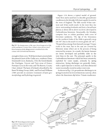
Figure 2.10 shows a typical model of ground-
water flow and is used here to describe groundwater
conditions in the Mendip Hills karst aquifer located in
the west of England. The hills extend 50 km east–
west and 10 km north–south. In the west they rise
above surrounding lowlands and form a broad karst
plateau at about 260 m above sea level, developed in
Carboniferous limestone. Structurally, the Mendips
comprise four en echelon periclines with cores of
Devonian sandstone. The dip of the limestones
on the northern limbs of the folds is generally steep
(60–90°) but to the south it is more gentle (20–40°).
The periclines emerge from beneath younger Triassic
Fig. 2.9 The disappearance of the upper River Fergus at An Clab,
rocks in the west, but in the east are covered by
south-east Burren, County Clare, Ireland, where surface runoff
Mesozoic strata which are in the process of being
from Namurian shales disappears into a swallow hole at the
contact with Carboniferous limestone. removed by erosion. As a result, the karstic features
are better developed and probably older in the
enough to form caves. Well-known karst areas include: west than in the east. The principal aquifer is the
the pinnacle karst of the Guilin area, southern China; Carboniferous limestone which has been extensively
Mammoth Caves, Kentucky, USA; the Greek Islands; exploited for water supply, primarily by spring
the Dordogne, Vercors and Tarn areas of France; abstraction. Spring discharges are generally flashy,
Postojna Caves in Slovenia; and The Burren, County with a rapid response to storms, such that abstracted
Clare, Ireland. The karst of Ireland is described by the water is normally stored in surface reservoirs.
Karst Working Group (2000), and Ford and Williams As shown in Fig. 2.10, groundwater discharge is via
(1989) provide an extensive treatment of karst geo- springs located at the lowest limestone outcrop, often
morphology and hydrology in general. where the limestones dip below Triassic mudstones.
Fig. 2.10 Block diagram showing the
occurrence of groundwater in karst
aquifers. After an original by T.C.
Atkinson.