
Page 51 - Hydrogeology Principles and Practice
P. 51
HYDC02 12/5/05 5:38 PM Page 34
34 Chapter Two
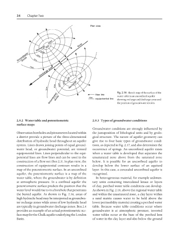
Fig. 2.16 Sketch map of the surface of the
water table in an unconfined aquifer
showing recharge and discharge areas and
the position of groundwater divides.
2.9.2 Water table and potentiometric 2.9.3 Types of groundwater conditions
surface maps
Groundwater conditions are strongly influenced by
Observation boreholes and piezometers located within the juxtaposition of lithological units and by geolo-
a district provide a picture of the three-dimensional gical structure. The nature of aquifer geometry can
distribution of hydraulic head throughout an aquifer give rise to four basic types of groundwater condi-
system. Lines drawn joining points of equal ground- tions, as depicted in Fig. 2.17, and also determines the
water head, or groundwater potential, are termed occurrence of springs. An unconfined aquifer exists
equipotential lines. Lines perpendicular to the equi- when a water table is developed that separates the
potential lines are flow lines and can be used in the unsaturated zone above from the saturated zone
construction of a flow net (Box 2.3). In plan view, the below. It is possible for an unconfined aquifer to
construction of equipotential contours results in a develop below the lower surface of an aquitard
map of the potentiometric surface. In an unconfined layer. In this case, a concealed unconfined aquifer is
aquifer, the potentiometric surface is a map of the recognized.
water table, where the groundwater is by definition In heterogeneous material, for example sedimen-
at atmospheric pressure. In a confined aquifer the tary units containing intercalated lenses or layers
potentiometric surface predicts the position that the of clay, perched water table conditions can develop.
water level would rise to in a borehole that penetrates As shown in Fig. 2.18, above the regional water table
the buried aquifer. As shown in Fig. 2.16, areas of and within the unsaturated zone, a clay layer within
high hydraulic head may be interpreted as groundwa- a sand matrix causes water to be held above the
ter recharge zones while areas of low hydraulic head lower permeability material creating a perched water
are typically in groundwater discharge zones. Box 2.4 table. Because water table conditions occur where
provides an example of an actual potentiometric sur- groundwater is at atmospheric pressure, inverted
face map for the Chalk aquifer underlying the London water tables occur at the base of the perched lens
Basin. of water in the clay layer and also below the ground