
Page 56 - Hydrogeology Principles and Practice
P. 56
HYDC02 12/5/05 5:38 PM Page 39
Physical hydrogeology 39
BO X
Potentiometric surface map of the London Basin
2.4
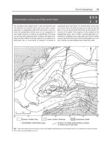
The recording of groundwater levels in wells and boreholes and groundwater levels (see Section 5.2). Potentiometric surface maps
their reference to a common datum such as sea level is a basic can also be used as the basis for constructing a regional flow net
requirement in hydrogeology. Maps of the water table or, more cor- (Box 2.3) and can provide useful information on the hydraulic con-
rectly, the potentiometric surface assist in the management of ductivity of the aquifer from inspection of the gradients of the
groundwater resources by enabling the identification of recharge equipotential contour lines. A further important application is in
and discharge areas and groundwater conditions. The repeat map- groundwater modelling where a high quality potentiometric surface
ping of an area enables the storage properties of the aquifer to be map and associated observation borehole hydrographs are neces-
understood from an examination of observed fluctuations in sary in developing a well-calibrated groundwater flow model.
Fig. 1 Map of the potentiometric surface of the Chalk aquifer underlying the London Basin drawn from observations made in January
1994. After Lucas and Robinson (1995).