
Page 58 - Hydrogeology Principles and Practice
P. 58
HYDC02 12/5/05 5:38 PM Page 41
Physical hydrogeology 41
Box 2.5, this situation developed in the Chalk aquifer 2.10 Classification of springs and
of the London Basin as a result of over-abstraction intermittent streams
of groundwater to sustain the growth of London’s
industry and population from between the early The classification of springs has been discussed from
1800s and the early 1960s. as early as Bryan (1919) who recognized the following
If the overlying geological unit behaves as an types: volcanic, fissure, depression, contact, artesian
aquitard then leakage of water to the underlying and springs in impervious rock. Simply defined,
aquifer can occur if a vertical hydraulic gradient is springs represent the termination of underground
developed across the aquitard–aquifer boundary. flow systems and mark the point at which fluvial pro-
This situation is commonly encountered where cesses become dominant. The vertical position of the
fluvial or glacio-fluvial silts and sandy clays over- spring marks the elevation of the water table or a
lie an aquifer and results in a semiconfined aquifer minimum elevation of the potentiometric surface
condition. A more complete regional hydrogeolo- at the point of discharge from the aquifer. The influ-
gical interpretation requires the combination and ence which springs exert on the aquifers they drain
analysis of mapped geological and geomorpholo- depends principally upon the topographic and struc-
gical information, surveyed groundwater-level data tural context of the spring. Ford and Williams (1989)
and hydrogeological field observations. As an ex- discuss hydrogeological controls on springs and recog-
ample of such an integrated approach, groundwater nize three principle types of springs (free draining,
conditions prevailing in the Qu’Appelle Valley of dammed and confined), principally in relation to
Saskatchewan are explained in Box 2.6. Interpretation karst aquifers in which some of the world’s largest
of the relationship between geology, groundwater springs occur (Table 2.2).
occurrence and potentiometric head distribution With reference to Fig. 2.19, free draining springs
demonstrates the connection between groundwater experience groundwater discharge under the influ-
and spring-fed lakes in this large glacial meltwater ence of gravity and are entirely or dominantly in the
channel feature. unsaturated (vadose) zone. Dammed springs are a
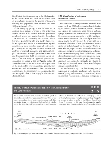
History of groundwater exploitation in the Chalk aquifer of BO X
the London Basin 2.5
The industrial revolution and associated population growth of outcrops to the south and north-west of London (Fig. 1) and is
Greater London resulted in a large demand for water. With surface confined by Tertiary strata, mainly Eocene London Clay. The aquifer
water resources becoming polluted, increasing use was made of the is recharged at outcrop by rainfall on the Chiltern Hills and North
substantial storage in the Cretaceous Chalk aquifer that underlies Downs. A component of this water flows through the aquifer
the London Basin. The Chalk forms a gentle syncline with extensive towards and along the easterly dipping axis of the syncline. Prior to
Fig. 1 Schematic geological section across the London Basin. The vertical scale is greatly exaggerated. After Sherlock (1962).