
Page 57 - Hydrogeology Principles and Practice
P. 57
HYDC02 12/5/05 5:38 PM Page 40
40 Chapter Two
BO X
Continued
2.4
A map of the potentiometric surface of the Chalk aquifer below potentiometric surface is less than 10 m below sea level. Additional
the London Basin is shown in Fig. 1 and illustrates a number of the disturbance of the regional groundwater level is noticeable along
above points. Areas of high groundwater level in excess of 50 m the River Lea valley to the north of London where large abstractions
above sea level are present in unconfined areas where the Chalk is have disturbed the equipotential contours. To the east of Central
exposed on the northern and southern rims of the synclinal basin. London, the Chalk potentiometric surface is at about sea level along
Here, the Chiltern Hills and North Downs are the recharge areas for the estuary of the River Thames and here saline water can intrude
the London Basin. In the centre of the Basin, the residual drawdown the aquifer where the overlying Lower London Tertiaries and more
in Chalk groundwater levels due to earlier over-exploitation of the recent deposits are thin or absent.
aquifer (Box 2.5) is clearly visible in the wide area where the Chalk
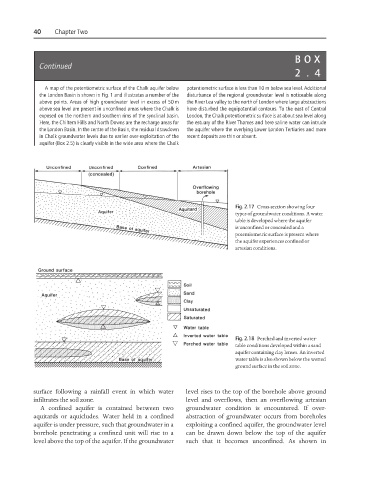
Fig. 2.17 Cross-section showing four
types of groundwater conditions. A water
table is developed where the aquifer
is unconfined or concealed and a
potentiometric surface is present where
the aquifer experiences confined or
artesian conditions.
Fig. 2.18 Perched and inverted water-
table conditions developed within a sand
aquifer containing clay lenses. An inverted
water table is also shown below the wetted
ground surface in the soil zone.
surface following a rainfall event in which water level rises to the top of the borehole above ground
infiltrates the soil zone. level and overflows, then an overflowing artesian
A confined aquifer is contained between two groundwater condition is encountered. If over-
aquitards or aquicludes. Water held in a confined abstraction of groundwater occurs from boreholes
aquifer is under pressure, such that groundwater in a exploiting a confined aquifer, the groundwater level
borehole penetrating a confined unit will rise to a can be drawn down below the top of the aquifer
level above the top of the aquifer. If the groundwater such that it becomes unconfined. As shown in